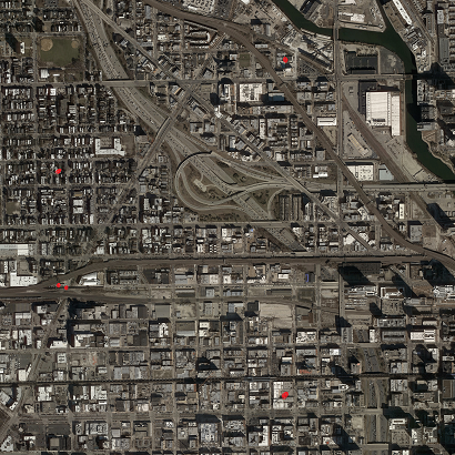
When actually running it, RoadTracer performs best if it starts from many starting locations that are automatically detected by another approach. Otherwise, if the city has weakly connected components (e.g. separated by river), RoadTracer may not be able to discover roads in all of the components. I pushed code to do this in this commit https://github.com/mitroadmaps/roadtracer/commit/e5fda4324aa199554d29276ea03994c0a5442fbe
Without the "-e" option, the MANUAL_POINT is still ignored if USE_TL_LOCATIONS=True (which it is by default). Instead, the code will pick a random starting point from the set of starting locations pulled from the ground truth data in starting_locations.json (generated from dataset/4_startlocs.go). It will only use one starting location though.
You can see the logic at https://github.com/mitroadmaps/roadtracer/blob/master/roadtracer/infer.py#L289
To use MANUAL_POINT you need to set USE_TL_LOCATIONS=False.
Regarding actual question, MANUAL_POINT should be measured from bottom left of the tile (first coordinate is # pixel to the right of bottom left, and second is # pixel up from bottom left). But I don't know what (2560, 522) is for, I agree in Chicago it is in middle of building so doesn't seem like it was for Chicago.
Sorry for the confusion!
Hi, Thanks for publishing the implementation of Roadtracer. Its performance is remarkable on the chicago region.
I want to ask : Where does
MANUAL_POINT1andMANUAL_POINT2belongs to in image tiles? It seems that it must belong to some point inchicago_-1-2_sat.png. So I tried locating those two manual points(considering top_left, bottomleft as origin and switching x,y coordinates), but there isn't any road.  Image is rescaled for uploading it on github but I was locating it on original resolution.