-
We have a few dataloggers that also record specific conductivity, in addition to temperature and water level. This data needs to be added as well.
-
**Problem**
Similar to the issue here https://github.com/WSWCWaterDataExchange/WestDAAT/issues/208, smaller subsets of data (out of millions) are hard to visualize in Mapbox. This could be a solution…
-
Don't think this is used by raadtools, but in case it is: the World Ocean Atlas data has moved from ftp.nodc.noaa.gov to data.nodc.noaa.gov
-
See general background detail here https://github.com/NewGraphEnvironment/restoration_framework/issues/6
Looks like we have real-time water temp datasets for the Bulkley at gov hydrometric stations…
-
I came across this project a while ago and seeing what it does and what are the input requirements, I believe OpenStreetMap (OSM) provides all the necessary data for this project.
This got me think…
-
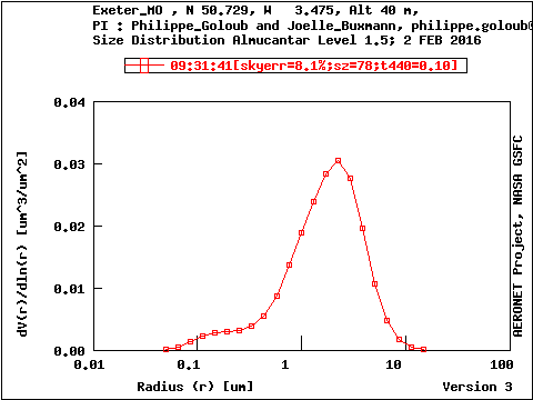
Source data from AERONET: https://aeronet.gsfc.nasa.gov/cgi-bin…
-
**Bug description**
In many places, there are no lakes where there should be lakes.
Need to do some sort of global compare of natural features between osm & ohm and see what's missing & then repla…
-
When fetching data that goes beyond the last datapoint, the current internal state that contains the data for the last (yet unsaved) datapoint is never returned.
I'd expect the last datapoint to be 1…
-
https://www.theguardian.com/world/2023/jul/11/uruguay-drought-water-google-data-center
https://www.reddit.com/r/FuckNestle/comments/14xo54u/not_only_nestle_its_pillage_thirsty_uruguayans/
-
Reported by Zelalem Tessema,@sujata91, and myself:
It would be great if the streamflow gauges could be specified with `RANK` or `subbasin` values in the vector-based setup, rather than coordinates.…