 OldGazer
commented
2 years ago
OldGazer
commented
2 years ago That is a good idea. I get similar functionality from ArduPilot/ArduCopter and Mission Planner. AP logs the data, MP converts the data, and GE plots and displays the data.
Sent from Yahoo Mail on Android
On Sun, May 29, 2022 at 9:51 AM, @.***> wrote:
It would be great if you could implement a conversion script in Ethos Suite to convert the GPS log files into a format compatible to Google Earth.
So that the result looks something like this: https://www.sm-modellbau.de/media/image/product/358/lg/gps-logger-3~3.jpg
Does anybody know which format is necessary to get such a result?
— Reply to this email directly, view it on GitHub, or unsubscribe. You are receiving this because you are subscribed to this thread.Message ID: @.***>
 strgaltdel
 mawzthefinn
 KevinFairgrieve
 j-watkiss
 agibson2
 keiner0815
 bsongis-frsky
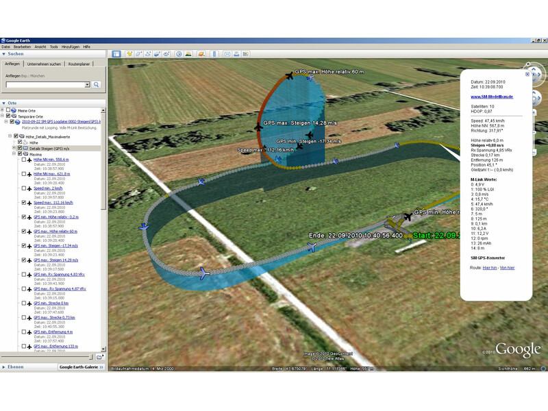
It would be great if you could implement a conversion script in Ethos Suite to convert the GPS log files into a format compatible to Google Earth.
So that the result looks something like this: https://www.sm-modellbau.de/media/image/product/358/lg/gps-logger-3~3.jpg
Does anybody know which format is necessary to get such a result?