Lars-Ki / px4_rrt_avoidance

A UAV collision avoidance package for px4 applications
MIT License
9 stars 7 forks source link

local_map and project_map #8

Closed mjmyt closed 1 year ago

mjmyt commented 2 years ago

Hi Lars-Ki,you are so patient.Unfortunately, I meet a new problem. when I adjust pixel_size with 0.1m and safety distance radius with 0.5.I find the centre of local_map is not aligned with project_map,As shown in the picture:first photo is in your paper,the second is my. 2 1

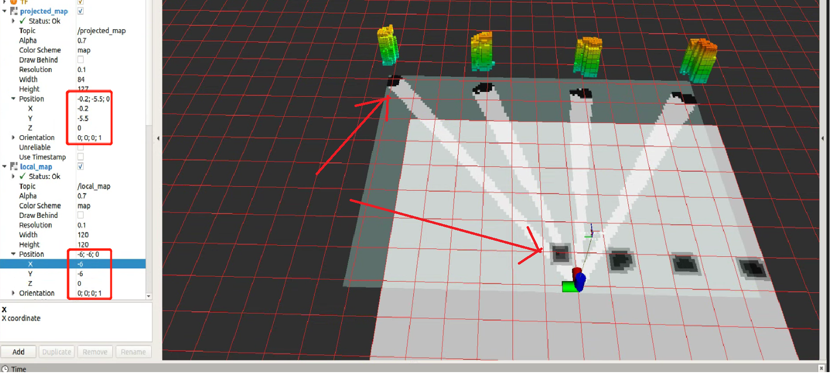
Where do I need to modify it in local_map_publisher.py Look forward to your reply and Thanks again。

Lars-Ki commented 2 years ago

Hi mjmyt Hopefully, I understood your question correctly. The local_map and the projected_map are not supposed to be aligned. As you continue your mission your projected_map (or also called global map [because it has all the information about the occupancy of the world at some point]) grows. The passage you want to find a solution for is only a fraction of the size of the global_map. For this, you don't want the local map to be too big because it increases calculation time. In the second gif in the README you see that the local map changes over time. This is intended.

Hope that helped.

Best regards,

Lars-Ki

Lars-Ki commented 2 years ago

Oh, sorry, I just realized my error. You mean in the local_map, the occupied cells are not underneath the actual obstacles. Was this the question?

mjmyt commented 2 years ago

Hi Lars-Ki,yes. In the local_map, the occupied cells are not underneath the actual obstacles. when I change the pixel_size、safety distance radius、global map resolution as you suggested.I find occupied cells that was far away from the actual obstacle.(around 7 meters).I think after modifying these three parameters(pixel_size、safety distance radius、global map resolution), I should also change other parameters.But I don't know which parameters to change。

Because,the realization of obstacle avoidance mainly depends on local_map,but now, the mapping position of the actual obstacle on the local_map is incorrect .

The task I want to achieve is to pass through the middle of the obstacle area,instead of bypassing the entire area(like the picture show), 无标题

Look forward to your reply.Thank you very, very, much。

mjmyt commented 2 years ago

Hi Lars-Ki,I have solved the last problem (the parameters you mentioned), But I have another question: I want to replace the rrt algorithm with other algorithms (such as informed-rrt), can I only modify the rrt* algorithm in local_planner.py? (I mean to regard your code as a framework, only need to modify the path planning algorithm) image image Or do you have any other suggestions? Look forward to your reply

Lars-Ki commented 2 years ago

Hi mjmyt

sorry for the late reply. I am glad to hear that you managed to solve the obstacle position error. Would you like to share your code and create a merge request or a new branch etc?

As far as I remember, you can now swap any desired path-planning algorithm with the currently existing one and publish potential solutions accordingly to the topic/message type, then master_node will accept the potential paths. If you are investigating a specific algorithm please keep in mind that the master_node is smoothing the path as it will check if it can reach the second next position point directly. If you would like to turn this off, you will need to adjust another line of code (Line 1439 of master_node. Just comment this line out and it should be fine.

I hope this helps for now. If it does not work, feel free to leave another comment.

mjmyt commented 2 years ago

Hi Lars-Ki, Sorry to bother you again. Do you know how to use Python to visualize the rrt* path planning process in rviz in this project?like this image

Lars-Ki commented 2 years ago

Hi mjmyt,

no worries I am happy to help. I assume you would like to see all random nodes created by the RRT correct? This is a little bit more complicated. You would have to publish a path with each iteration step of the RRT algorithm. Calculationtimewise this is a very bad idea. I have only Implemented a current path visualization tool here You would have to adjust this or find a better idea.

Good luck

Lars-Ki commented 1 year ago

No activity. Closing Issue