Liverpool-UK / somebody-should

A place to collect issues/suggestions/to-do items for the city of Liverpool
10 stars 1 forks source link

How could Liverpool become a "15 minute city"? #35

Open amcewen opened 4 years ago

amcewen commented 4 years ago

Via Dan Hill's excellent (if extensive :-) Slowdown Papers I learnt of Paris' plans for a "15 minute city":

This simple notion — that all your basic everyday needs, from education to commerce to healthcare to culture and so on, are located within 15 minutes walk or bike of your front door

That seems to me like a good tool for thinking about how to make the city more walkable, and to explore how the city might adapt to include more local, distributed approaches (particularly post-pandemic and with an increasing climate crisis).

A few years back, the Liverpool Architectural Society ran the Integrated City Project, which had some echoes of this. I'm not sure much of it ever ended up online, and now all I can find is my blog post about it.

However, it does give us this interesting map of 32 areas of the city, which we could take as a starting point to see how we fare at the moment.

A map of Liverpool showing the 32 areas spread across it

Lots of these areas have existing focal points for shops, libraries, etc. Maybe we can identify gaps that we can work to fill, or barriers that make it hard for the flow of people between neighbouring areas. Or maybe we'll realise we already have a 15-minute city, and we just need to think about it differently.

amcewen commented 
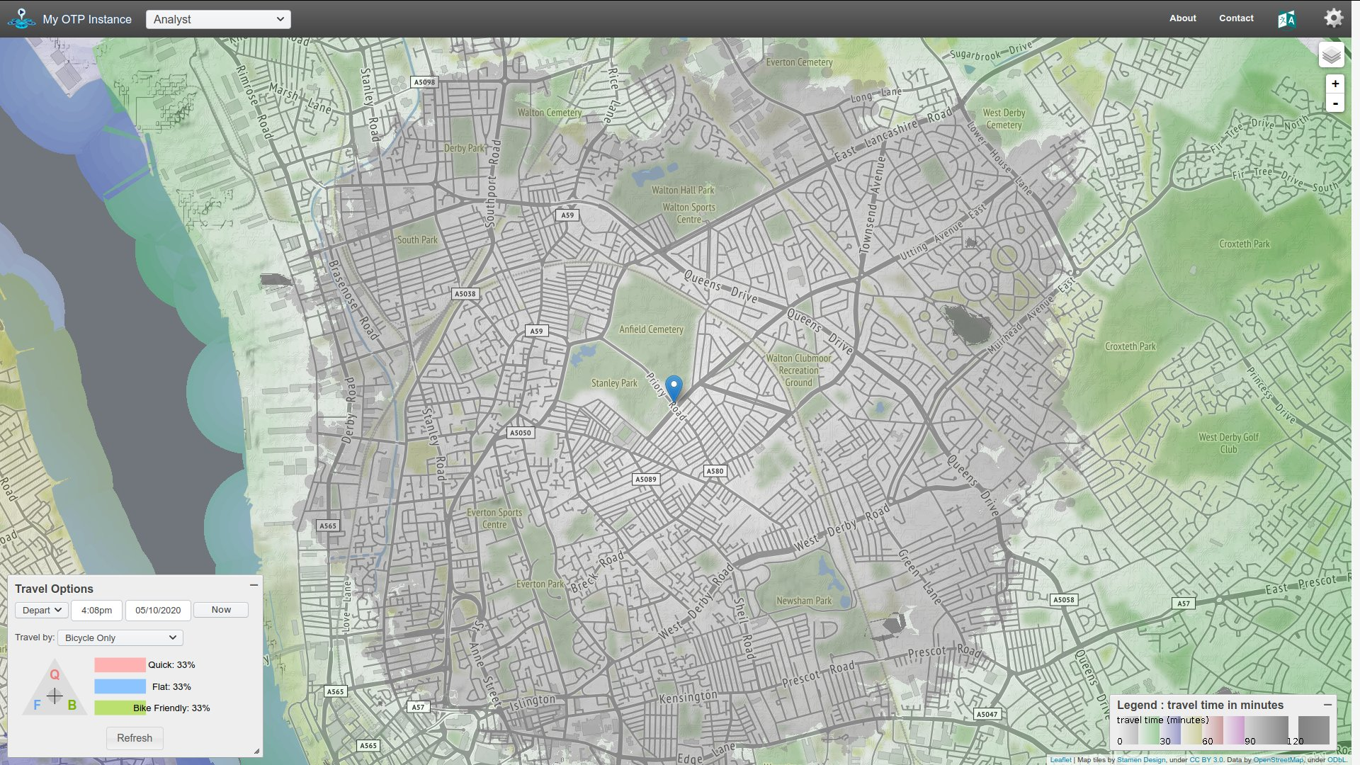
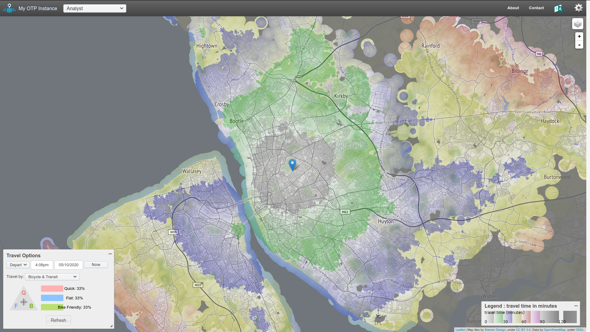
4 years ago

I'm going to see how easy it would be to pull together a map showing some travel time contour areas for those 32 districts (i.e. how far you can get in 15 minutes of walking, or cycling, from—for example—St. Mary's church in West Derby). It looks like OpenTripPlanner can help build that sort of thing, which means I can make some progress on #34 too :grinning:

amcewen commented 4 years ago

Having gotten an initial version of OpenTripPlanner up and running, it generates time travel isochrones like this (grey is 15 minutes walk to/from DoES Liverpool, green is 30 minutes...):

image

amcewen commented 4 years ago

The time travel isochrone is great fun. Picking Anfield as the centre, we can look at...

Walking

image

Cycling

image

Cycling with the option of putting the bike on the train too

image

Try it yourself

If you want to play around with it...

  1. Go to trips.mcqn.com/ (or http://209.97.132.40 if that's not working)
  2. Zoom into the bit of Merseyside you're interested in (as it's only got data for Merseyside)
  3. Change from Multimodal Trip Planner to Analyst in the drop-down menu at the top
  4. Right-click on the map at the place you want as the centre for your isochrone and choose Set as Analysis Location
  5. Choose the Travel Options you're interested in from the dialog in the bottom-left corner
  6. Zoom out to the area you're interested in (I think it limits the calculations to what's visible when you first generate the isochrone)
  7. Hit the Refresh button in the Travel Options dialog
  8. Wait for the spinner to finish. I sometimes found dragging the map round after that would make the travel contours show up
amcewen commented 4 years ago

There's also an API for it, so, for example, http://trips.mcqn.com/otp/routers/default/isochrone?fromPlace=53.4105095,-2.9704659&mode=WALK&date=05-05-2020&time=8:00am&cutoffSec=300&cutoffSec=600&cutoffSec=900 will give you a JSON representation of the 5, 10 and 15 minute walk time contours around DoES Liverpool.

I think the next steps might include:

Anything else? Anyone else want to help with any of this?

davidtweaver commented 4 years ago

I'd be interested in helping you somehow! I'm on furlough, so I'm looking for interesting projects to hack away on

amcewen commented 4 years ago

Haven't had a lot of time to work on this, but did fight with building OpenTripPlanner from source last weekend. Managed to build the dev-2.x branch, but that didn't seem to have the isochrone stuff working in it (or I couldn't work out how to turn it on).

However, when trying to debug that all, I happened upon this site showing how easy/hard it is to get to schools in Amsterdam. That has a Jekyll/Leaflet.js/Turf.js front end, which then calls to an OpenTripPlanner instance behind the scenes to generate the isochrones.

It seems that's probably a better approach here, given (for the #15MinuteCity approach) we don't need the trip planner element that's front-and-centre of OpenTripPlanner.

I've spun up a new repo to try that out.

@davidtweaver, if you're still up for helping out that'd be ace. I guess there'll be a bit of Ruby for any customisation of Jekyll (I expect there'll at least be some generating isochrones at build time, maybe not much more) and then a bunch of Javascript to load the isochrones, let people generate one for where they live, etc. (I haven't used Leaflet or Turf before). Let me know what takes your fancy...

unusualevent commented 9 months ago

that's so cool!