 hellkite500
commented
3 years ago
hellkite500
commented
3 years ago @fred-ogden you may be interested in following this discussion.
Open hellkite500 opened 3 years ago
hellkite500
commented
3 years ago @fred-ogden you may be interested in following this discussion.
hellkite500
commented
3 years ago Here is another, somewhat simpler, diagram of the conceptual waterbody relationship in HY_Features.
 mikejohnson51
commented
3 years ago
mikejohnson51
commented
3 years ago After some follow up with @hellkite500 we are going to test two approaches. One that adds the waterbody/channel attributes to the flowpaths geojson similar to the above example, as well as one that is closer(?) to the HY_Features specification in which all water body information is stored as a separate JSON file with appropriate nexus, flowpath, and catchment references.
Maybe something like:
{
    "name": "waterbody_data",
    "features": [
        {"type": "Feature", "id": "wb-1", "properties":
         {
              "type": "HY_River",
              "cross_sections": [
                       {"nex-id":"id1", "cs-id":1, "width":123, "paramB":"valueB"},
                       {"nex-id":"id2", "cs-id":2, "width":123, "paramB":"valueB1"}
                   ],
               "longitudal_sections": [
                       {"nex-id":"id1", "cross_section":"cs-1", "length":123, "paramB":"valueB"},
                       {"nex-id":"id2", "cross_section":"cs-2", "length":123, "paramB":"valueB1"}
                   ],
              "flowpath_id": "fp-1",
              "realized_catchment":  "cat-1"
          }
        }
    ]
}
Background and reference
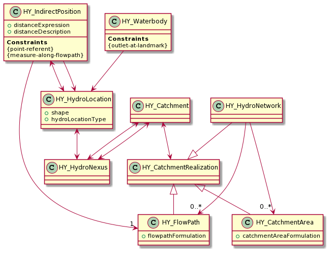
This is an attempt to begin formalizing the framework's handling and integration of HY_Waterbody. A more detailed relationship of
HY_Waterbodycan be seen here. A HY_Catchment has a one-to-one mapping to a HY_Flowpath. This flowpath is the logical conveyance mechanism for hydrologic information from the upstream HY_Nexus to the downstreamHY_Nexus. So logically, aHY_Catchmentproduces lateral flow to aHY_Flowpath, which may then map that flow to the downstream nexus. Currently, aHY_Catchmentinteracts directly with the downstream Nexus, which semantically is the same as as theHY_Catchmentcontributing flow to the associatedHY_Flowpathwhich then conveys water to theHY_Nexus.Implementing these semantics opens up the integration of hydro-dynamic routing using
HY_Waterbody, where theHY_Catchmentcontributes to aHY_Flowpath, which is linked (potentially one-to-many) to a set of waterbodies (and the waterbodies' internal cross/longitudal sections). These waterbody classes are then responsible for deciding how flow ultimately gets to the downstream nexus.To ultimately route flow, we need several key pieces of information
routelinkdata which provides channel properties for each COMID in the NHDPlus networkAn example waterbody geojson might look like:
Note, the "realized_catchment" key and "flowpath_id" key may or may not be appropriate, still looking at the correct way to attach this to the overall topology.
This issue serves as a place to work through the definitions, format, and required information to define waterbodies in a meaningful context for the ultimate purpose of connecting them to some routing mechanic.
@dblodgett-usgs @mikejohnson51 @robertbartel @donaldwj what are your thoughts, and any next steps you can think of we need to work on on the hydrofabric or ngen support?
@jdmattern-noaa @jameshalgren I think we can extend this into the t-route ngen to better represent the t-route network using the waterbody cross/longitudal sections as the routing segments, and could use that as our initial routing test.