OSMPH / papercut_fix

Tracking data fixing requests for the OSMPH community
9 stars 2 forks source link

Lupang Arenda, Santa Ana, Taytay community mapping collaboration #54

Open maning opened 5 years ago

maning commented 5 years ago

We had a great fieldmapping at Lupang Arenda today! Thanks to all who volunteered! See this ticket for context of the collaboration.

Screenshot 2019-07-07 20 21 22
The crew

Screenshot 2019-07-07 19 23 52
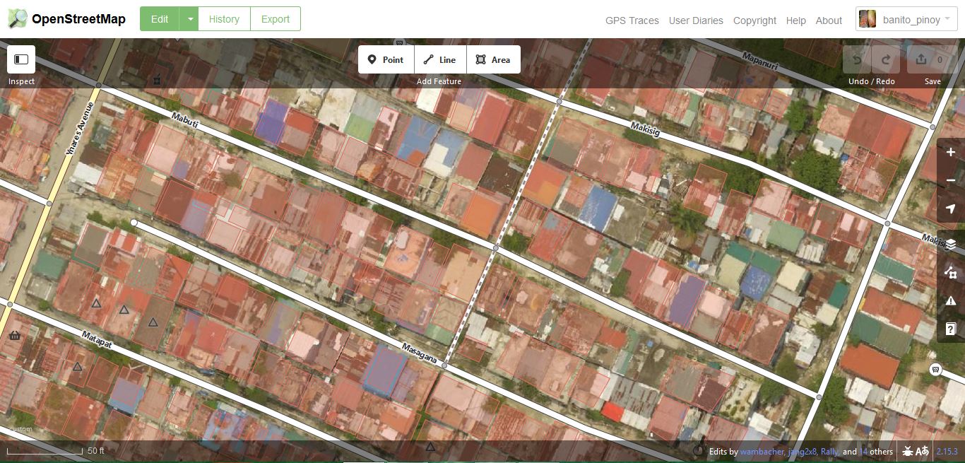
[WIP] left-Bing imagery, right-sample orthophoto from drone captures

I'm outlining some key actions to people involved, let's use this ticket as public record of the further work.

maning commented 5 years ago

Processing drone imagery with OpenDroneMap

Screenshot 2019-07-08 14 07 30
``` gdalinfo /Users/maningsambale/Projects/odm/bunny1_orthophoto/odm_orthophoto.original.tif Driver: GTiff/GeoTIFF Files: /Users/maningsambale/Projects/odm/bunny1_orthophoto/odm_orthophoto.original.tif Size is 16589, 9006 Coordinate System is: PROJCS["WGS 84 / UTM zone 51N", GEOGCS["WGS 84", DATUM["WGS_1984", SPHEROID["WGS 84",6378137,298.257223563, AUTHORITY["EPSG","7030"]], AUTHORITY["EPSG","6326"]], PRIMEM["Greenwich",0, AUTHORITY["EPSG","8901"]], UNIT["degree",0.0174532925199433, AUTHORITY["EPSG","9122"]], AUTHORITY["EPSG","4326"]], PROJECTION["Transverse_Mercator"], PARAMETER["latitude_of_origin",0], PARAMETER["central_meridian",123], PARAMETER["scale_factor",0.9996], PARAMETER["false_easting",500000], PARAMETER["false_northing",0], UNIT["metre",1, AUTHORITY["EPSG","9001"]], AXIS["Easting",EAST], AXIS["Northing",NORTH], AUTHORITY["EPSG","32651"]] Origin = (296108.531677999999374,1607653.094869999913499) Pixel Size = (0.049998330399662,-0.049995508549838) Metadata: AREA_OR_POINT=Area Image Structure Metadata: COMPRESSION=DEFLATE INTERLEAVE=PIXEL Corner Coordinates: Upper Left ( 296108.532, 1607653.095) (121d 6'28.09"E, 14d32' 3.14"N) Lower Left ( 296108.532, 1607202.835) (121d 6'28.22"E, 14d31'48.49"N) Upper Right ( 296937.954, 1607653.095) (121d 6'55.79"E, 14d32' 3.36"N) Lower Right ( 296937.954, 1607202.835) (121d 6'55.92"E, 14d31'48.71"N) Center ( 296523.243, 1607427.965) (121d 6'42.01"E, 14d31'55.92"N) Band 1 Block=512x512 Type=Byte, ColorInterp=Red Mask Flags: PER_DATASET ALPHA Band 2 Block=512x512 Type=Byte, ColorInterp=Green Mask Flags: PER_DATASET ALPHA Band 3 Block=512x512 Type=Byte, ColorInterp=Blue Mask Flags: PER_DATASET ALPHA Band 4 Block=512x512 Type=Byte, ColorInterp=Alpha ```

Details of processing time below:

command # images size (MB) runtime
time docker run -it --rm -v "$(pwd)/bunny1:/code/images" -v "$(pwd)/bunny1_orthophoto:/code/odm_orthophoto" opendronemap/odm 70 350 real 102m58.414s
user 0m0.280s
sys 0m0.215s
time docker run -it --rm -v "$(pwd)/bunny3:/code/images" -v "$(pwd)/bunny3_orthophoto:/code/odm_orthophoto" opendronemap/odm 41 205 real 194m11.746s
user 0m0.314s
sys 0m0.361s
time docker run -it --rm -v "$(pwd)/bunny2:/code/images" -v "$(pwd)/bunny2_orthophoto:/code/odm_orthophoto" opendronemap/odm 55 270 real 256m1.920s
user 0m0.436s
sys 0m0.571s
time docker run -it --rm -v "$(pwd)/bunny4:/code/images" -v "$(pwd)/bunny4_orthophoto:/code/odm_orthophoto" opendronemap/odm 68 340 real 219m44.133s
user 0m0.501s
sys 0m0.668s
time docker run -it --rm -v "$(pwd)/bunny5:/code/images" -v "$(pwd)/bunny4_orthophoto:/code/odm_orthophoto" opendronemap/odm 90 450 real 224m35.409s
user 0m0.523s
sys 0m0.685s
govvin commented 5 years ago

Thank you for the update @maning and the tips for tweaking the Docker settings.

We collected 2,600 images but only 1,600 images uploaded to Mapillary, after removing duplicates.

govvin commented 5 years ago

Diary post by Maning: https://www.openstreetmap.org/user/maning/diary/390221

maning commented 5 years ago

Imagery now available in OAM: https://map.openaerialmap.org/#/121.11478328704835,14.537581224033948,15?resolution=high&_k=dqxutz

banitopinoy commented 5 years ago

The available flyover images in OpenAerialMap can now be used as WMS in QGIS Lupang Arenda WMS in QGIS.

OAM imagery can also used directly as background in OSM ID editor or JOSM OAM Lupang Arenda ID Editor

govvin commented 5 years ago

@banitopinoy , could you publish the stitched images to OAM? We could start doing mapathons to digitize the features in the area with a Tasking Manager (to avoid editing conflicts) while waiting for the completion of the remaining areas.

banitopinoy commented 5 years ago

@banitopinoy , could you publish the stitched images to OAM? We could start doing mapathons to digitize the features in the area with a Tasking Manager (to avoid editing conflicts) while waiting for the completion of the remaining areas.

All images are already available in OpenAerialMap: Thumbnail pics

govvin commented 5 years ago

Our CWTS volunteers from PUPSJ will be contributing to the Lupang Arenda mapping effort using Task 6228. Feel free to share the task, and lend a hand.

govvin commented 5 years ago

@banitopinoy I meant a stitched collection of all those imagery.

banitopinoy commented 5 years ago

The first image in the left corner is the stiched image.

govvin commented 5 years ago

@banitopinoy Gaaahh. I need new eyeglasses. Sorry for missing that.

maning commented 5 years ago

Draft imagery-index here: https://gist.github.com/maning/93fe6cd3ad3529eee7a95354ec99e63e These are the allowed values in the schema: https://github.com/osmlab/editor-layer-index/blob/gh-pages/schema.json

maning commented 5 years ago

Create PR to imagery-index to load Arenda Orthophoto from OAM as default imagery for OSM editors @maning

Done! https://osmlab.github.io/editor-layer-index/ Screen Shot 2019-07-31 at 10 28 29

maning commented 5 years ago

Reposting here @ralleon assessment on image alignment.

With Strava cycle heatmap on top of the "draft" drone imagery: Best-fitting heatmap on minor roads, with consideration of cyclist-bias (of not using the cyclelanes) on C6 Road, the general imagery offset was estimated to be around 0.74, -2.76 (with approx 0.8 meter repeatable error)

image image

maning commented 5 years ago

It's now available in iD master! Once a new release of iD becomes available to osm.org, this will be the top recommended imagery.

arenda_iD

maning commented 5 years ago

This is now available in osm.org's iD (v.2.15.5).

Screen Shot 2019-08-28 at 09 36 09

Are there any next actions in this ticket or good to close?

govvin commented 5 years ago

@maning Finding a workable schedule for the Arenda community and the drone pilot to cover remaining area of Arenda.

How's your schedule these days @leighmedy ?

maning commented 4 years ago

We did round 2 mission last Oct 12. Data is now available in OAM and soon directly in iD

This mission completes the coverage of the whole AOI. Thanks to all involved!

Photos!

photo_2019-10-16_15-41-40 photo_2019-10-12_22-42-53 photo_2019-10-16_15-41-55 photo_2019-10-16_15-42-00

maning commented 4 years ago

PR to update the coverage of Arenda in the editor-layer-index was rejected. I will start a fresh PR after getting clarity on the process to be outlined by the repo maintainers.

maning commented 4 years ago

Marianne and Kath would like to print a map of CELO coverage within Lupang Arenda. They will use the map to showcase the progress of mapping to the community. The CELO mapped buildings are here.

Requirements: Poster size or larger (2x3 or 4x8 feet) map showing the CELO tagged buildings, drone imagery, additional context like roads, purok boundaries.

telegram chat:

Screenshot 2020-03-19 20 03 08 Screenshot 2020-03-19 20 03 36
banitopinoy commented 4 years ago

Possible to print in large format and it might be more practical if it will printed on a tarpaulin. A 4x8ft print would cost around P500. There is a good print shop in Concepcion Uno in Marikina which I have tried that can do the job. Main constraint is that we have this current pandemic concern. MM is lock down and print shops are temporarily close.

govvin commented 4 years ago

image

Pending tasks