
Open mapconcierge opened 3 years ago


<img width="970" alt="スクリーンショット 2021-02-18 15 13 33" src="https://user-images.githubusercontent.com/416977/108313603-ef45ef80-71fb-11eb-9150-693a0c24fae1.png">

<img width="1075" alt="スクリーンショット 2021-02-18 15 12 37" src="https://user-images.githubusercontent.com/416977/108313616-f4a33a00-71fb-11eb-9f1b-644237d430e4.png">

On 13 February 2021, the Fukushima-ken Oki (Fukushima Prefecture Offshore) earthquake (Japanese: 福島県沖地震, Hepburn: Fukushima-ken'Oki Jishin) with a magnitude of 7.1 earthquake struck offshore east of Tōhoku, Japan.

[https://en.wikipedia.org/wiki/2021_Fukushima_earthquake](https://en.wikipedia.org/wiki/2021_Fukushima_earthquake)On 13 February 2021, the Fukushima-ken Oki (Fukushima Prefecture Offshore) earthquake (Japanese: 福島県沖地震, Hepburn: Fukushima-ken'Oki Jishin) with a magnitude of 7.1 earthquake struck offshore east of Tōhoku, Japan.
Casualties
The earthquake resulted in at least 157 people injured across nine prefectures, with the most coming from Fukushima Prefecture.There, some 81 people were reported hurt. In Miyagi, the earthquake injured 57 residents. There were 17 people injured in Yamagata, Ibaraki, Gunma, Tochigi, Saitama, Chiba, and Kanagawa prefectures.Most of the injuries reported were minor, caused by glass cuts, however 12 victims were seriously injured. There are currently no deaths or missing individuals.

[https://en.wikipedia.org/wiki/2021_Fukushima_earthquake](https://en.wikipedia.org/wiki/2021_Fukushima_earthquake)国土地理院シームレス空中写真 https://cyberjapandata.gsi.go.jp/xyz/seamlessphoto/{z}/{x}/{y}.jpg
Building Mapping in Shinchi Town #hotosm-project-10391 #DRONEBIRD #FuruhashiLab #YouthMappersAGUSpecial Project Notes
====================
* GSI Seamless imagery loads automatically - Much clearer
* GSI Seamless imagery has better horizontal accuracy - Smaller horizontal accuracy
* Maxar Premium Imagery (Beta) is most latest dataset - Newest imagery
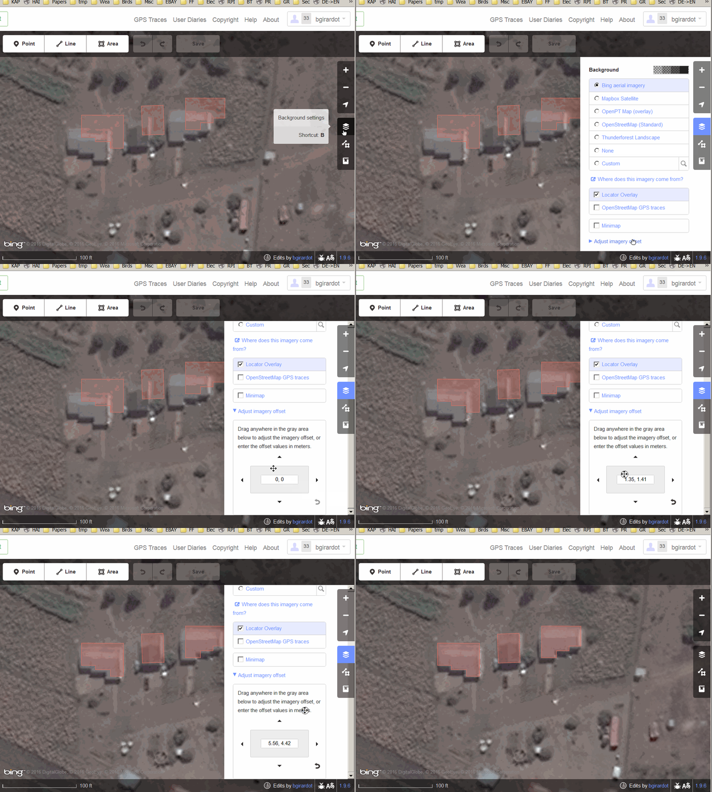
* If you want to use Maxar Premium Imagery (Beta), you should be adjust background imagery with GSI Seamless imagery.
* **Validators should validate to GSI Seamless imagery or Maxar Premium Imagery**
* You may need to align the imagery to the existing mapping - See below how to do that.
* **Buildings Only**
* Try to map individual buildings and not groups of buildings.
* Please be careful not to change or affect existing mapping unless you are local or very experienced.
## How to use Tasking Manager
[https://youtu.be/Pus2iFZphDU](https://youtu.be/Pus2iFZphDU)
## How to adjust background imagery in iD editor
On 13 February 2021, the Fukushima-ken Oki (Fukushima Prefecture Offshore) earthquake (Japanese: 福島県沖地震, Hepburn: Fukushima-ken'Oki Jishin) with a magnitude of 7.1 earthquake struck offshore east of Tōhoku, Japan.

[https://en.wikipedia.org/wiki/2021_Fukushima_earthquake](https://en.wikipedia.org/wiki/2021_Fukushima_earthquake)On 13 February 2021, the Fukushima-ken Oki (Fukushima Prefecture Offshore) earthquake (Japanese: 福島県沖地震, Hepburn: Fukushima-ken'Oki Jishin) with a magnitude of 7.1 earthquake struck offshore east of Tōhoku, Japan.
Casualties
The earthquake resulted in at least 157 people injured across nine prefectures, with the most coming from Fukushima Prefecture.There, some 81 people were reported hurt. In Miyagi, the earthquake injured 57 residents. There were 17 people injured in Yamagata, Ibaraki, Gunma, Tochigi, Saitama, Chiba, and Kanagawa prefectures.Most of the injuries reported were minor, caused by glass cuts, however 12 victims were seriously injured. There are currently no deaths or missing individuals.

[https://en.wikipedia.org/wiki/2021_Fukushima_earthquake](https://en.wikipedia.org/wiki/2021_Fukushima_earthquake)国土地理院シームレス空中写真 https://cyberjapandata.gsi.go.jp/xyz/seamlessphoto/{z}/{x}/{y}.jpg
Building Mapping in Yamamoto Town #hotosm-project-10393 #DRONEBIRD #FuruhashiLab #YouthMappersAGUSpecial Project Notes
====================
* GSI Seamless imagery loads automatically - Much clearer
* GSI Seamless imagery has better horizontal accuracy - Smaller horizontal accuracy
* Maxar Premium Imagery (Beta) is most latest dataset - Newest imagery
* If you want to use Maxar Premium Imagery (Beta), you should be adjust background imagery with GSI Seamless imagery.
* **Validators should validate to GSI Seamless imagery or Maxar Premium Imagery**
* You may need to align the imagery to the existing mapping - See below how to do that.
* **Buildings Only**
* Try to map individual buildings and not groups of buildings.
* Please be careful not to change or affect existing mapping unless you are local or very experienced.
## How to use Tasking Manager
[https://youtu.be/Pus2iFZphDU](https://youtu.be/Pus2iFZphDU)
## How to adjust background imagery in iD editor
BeginnerIntermediateAdvanced
M7.3 Earthquake Fukushima, 2021 Building Mapping. Shinchi Town, Fukushima, Japan
https://en.wikipedia.org/wiki/2021_Fukushima_earthquake
DRONEBIRD #FuruhashiLab #YouthMappersAGU
検討エリア(震度6強)
解析:建物被害推定(防災科研 SIP地震被害推定システム)
新地町 http://geojson.io/#map=11/37.9770/141.0363
山元町 http://geojson.io/#map=12/37.9422/140.8492
緊急度
航空写真タイル