datameet / maps

Repository for all spatial data.
http://projects.datameet.org/maps/
MIT License
379 stars 370 forks source link

Add official country and state boundaries of India from Survey of India #32

Closed planemad closed 5 years ago

planemad commented 5 years ago

The Survey of India has made the shapefiles of the official borders available on their online portal https://indiamaps.gov.in/soiapp/

Shapefiles: https://indiamaps.gov.in/SOIApp/downloadLayer/IndiaBoundary.zip https://indiamaps.gov.in/SOIApp/downloadLayer/StateBoundary.zip

Visually checked them and they look quite accurate except for some issues along the coastline. This can be used to replace some of the existing shapefiles in the repository.

devdattaT commented 
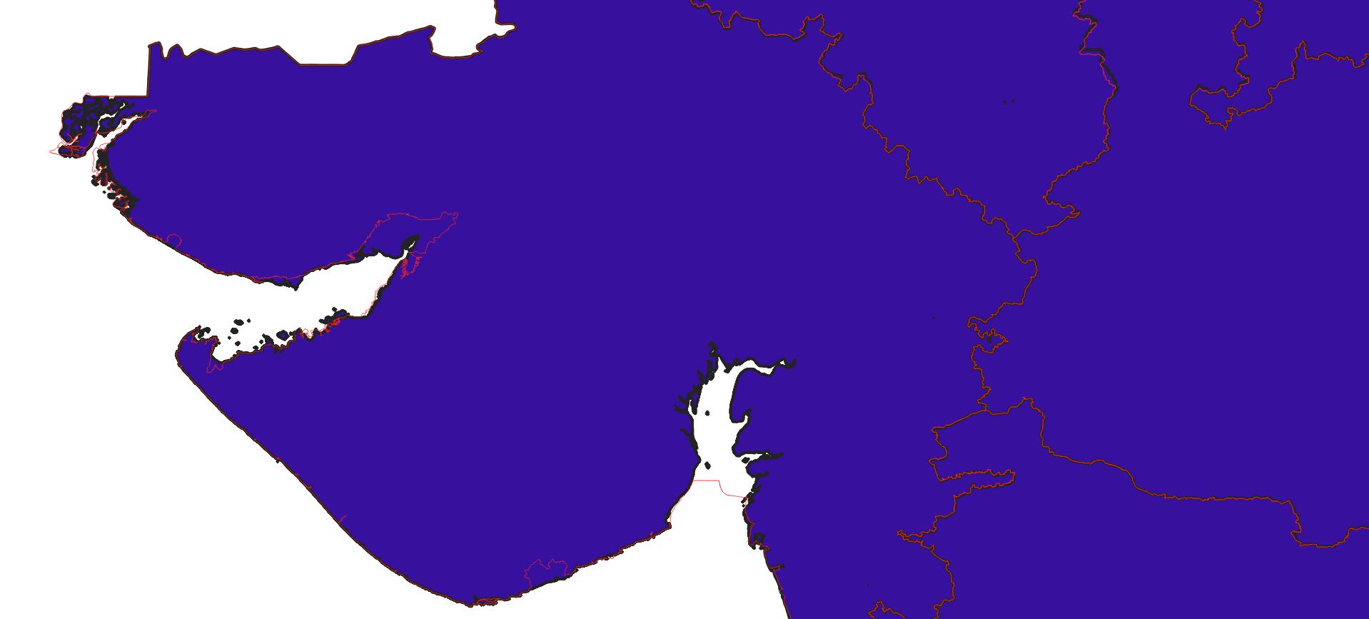
5 years ago

Thanks @planemad This dataset looks great in places, but at others, is extremly weird, and in some places wrong.

Some Examples (Blue with Black boundaries is existing State Boundary; Red is the SOI boundary) : Gulf of Kutch & Kabhat:

gujrat

Pondicherry Boundary:

pondy

Even the New AP/Telengana boundry does not match the one that they have at http://www.surveyofindia.gov.in/files/Telangana%20Map.pdf

planemad commented 5 years ago

You are right, the State boundaries might need some cleanup before use. Also found holes in Madhya Pradesh and Dadra Nagar Haveli

screen shot 2018-10-16 at 7 52 36 pm screen shot 2018-10-16 at 7 53 15 pm

The International boundary looks much better.

thejeshgn commented 5 years ago

It doen't mention Goverment Open Data License. But has

This Public Portal facilitates free access to accurate &amp; authoritative GIS-ready spatial data to empower, inform &amp; enrich every citizen<br>
            • Free use of data for Consultative, Research and Education purposes
            • Free access to various base maps viz Imagery, Hill Shade and Vector data
            • Citizens can annotate over the autorotative basemap and download the work done for their use
            • Citizens can download the approved boundary files for Consultative, Research and Education purposes

Practically all use except commercial. Should we write to them, to release under GODL?

planemad commented 5 years ago

Should we write to them, to release under GODL?

@thejeshgn yes its best to clarify if this comes under NDSAP+GODL

planemad commented 5 years ago

Also to note that this dataset does not fall in the negative list of products from SoI. Does that mean it automatically comes under GODL or does that need to be explicitly stated?

cc @naveenpf

naveenpf commented 5 years ago

Better is when it is released explicitly. We community should write to DST and SOI to appoint a CDO for SOI. If datameet,cis all supporting orgs request SOI, they will understand the need.

thejeshgn commented 5 years ago

We can write one as DataMeet community.

thejeshgn commented 5 years ago

Should I start a letter for coediting?

thejeshgn commented 5 years ago

@devdattaT @planemad @naveenpf

  1. Also should we add them to the under https://github.com/datameet/maps/tree/master/Survey-of-India-Index-Maps As shapefiles, without changing format.

  2. Also we can share on the group

thejeshgn commented 5 years ago
  1. Added https://github.com/datameet/maps/tree/master/Survey-of-India-Index-Maps

  2. Discussion on the list - https://groups.google.com/forum/#!topic/datameet/gRRSDXDiEeY

thejeshgn commented 5 years ago

Screenshots for the record

soi_external_boundaries_download soi_external_boundaries_note

planemad commented 5 years ago

This is done!

answerquest commented 2 years ago

as of 2022-04-29, SOI website has shared a shapefile on https://surveyofindia.gov.in/pages/outline-maps-of-india for India International boundary vector format. It is in CRS LLC_WGS84 and isn't very accurate at higher zooms esp around islands and coastlines. But I guess that's the most "official" one available. Should that be added here for completion sake?

planemad commented 2 years ago

@answerquest definitely makes sense to archive a copy on the maps repo

thejeshgn commented 2 years ago

@devdattaT and @planemad here it is https://github.com/datameet/maps/pull/76 for archival purpose.