 kocio-pl
commented
6 years ago
kocio-pl
commented
6 years ago What about landuse=religious?
Open geowas-github opened 6 years ago
kocio-pl
commented
6 years ago What about landuse=religious?
 matkoniecz
commented
6 years ago
matkoniecz
commented
6 years ago Yes, can you give case where landuse is tagged and amenity=monastery still needs a separate label?
 dieterdreist
commented
6 years ago
dieterdreist
commented
6 years ago sent from a phone
On 26. Jan 2018, at 06:18, Mateusz Konieczny notifications@github.com wrote:
Yes, can you give case where landuse is tagged and amenity=monastery still needs a separate label?
IMHO monasteries are interesting features of their own, regardless of landuse. Landuse=religious is not working well (both are properties and not features, “religion=*” already says something is religious, and landuse is a property as well).
 geowas-github
commented
6 years ago
geowas-github
commented
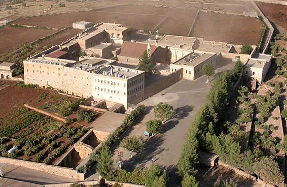
6 years ago Look at the example above: Mor Gabriel Monastery in SE Turkey: https://www.openstreetmap.org/way/555465696 Everything within the ring wall is the monastery. In the centre a church (amenity=place_of_worship) and the other main buildings around it (accomodation, refectory, ...). The area between these building in my opinion is the part which is the "religious" land (landuse = religious). Around it we have farmland and grazing land for the cattle (everything north).
http://www.morgabriel.org/pages/1.html http://www.morgabriel.org/pages/48.html https://en.wikipedia.org/wiki/Mor_Gabriel_Monastery
 polarbearing
commented
6 years ago
polarbearing
commented
6 years ago If we make progress with the outlines, this might be a solution for the monastery as well.
 Tomasz-W
commented
5 years ago
Tomasz-W
commented
5 years ago I propose to re-use landuse=religious rendering here (https://github.com/gravitystorm/openstreetmap-carto/pull/3493).
kocio-pl
commented
5 years ago I was first! :smile: We just need somebody to code it.
polarbearing
commented
5 years ago I'm still sceptical to use a landuse colour for it. A monastery can be quite large and comprise different landuses, including farmland. I'd prefer an outline.
kocio-pl
commented
5 years ago Smaller landuses will be visible then.
polarbearing
commented
5 years ago The smaller landuses yes, but not the boundary. Imagine a monastery where the core buildings are surrounded by farmland, a typical constellation.
 Adamant36
commented
5 years ago
Adamant36
commented
5 years ago @polarbearing, is it bad mapping practice to map landuse inside/on top of another larger landuse area? People here in America do it a lot and I've always wondered about it.
matkoniecz
commented
5 years ago Depends on whatever it is a correct representation of reality. In many cases it is - for example it may be
it is mostly result of landuse values not always excluding each other
polarbearing
commented
5 years ago Yes and in this particular case it is smaller landuses within a larger amenity=monastery
Adamant36
commented
5 years ago Thanks for the explanation. Going by that it seems that the smaller landuses inside the monastery might not be an issue. Or, maybe im wrong?
polarbearing
commented
5 years ago As said, you would not see where the monastery ends when the core buildings are surrounded e.g. by gaplessly mapped farmland.
kocio-pl
commented
5 years ago I think this is systematic problem, so monasteries wouldn't be an exception and at least we have a working color for similar objects. I know parks and hospitals covered almost completely with grass or trees.
I usually refer to the example is this hospital - only some patches of the area background are visible, but the shape is hard to guess:
https://www.openstreetmap.org/way/66266360

dieterdreist
commented
5 years ago Am Sa., 24. Nov. 2018 um 21:29 Uhr schrieb polarbearing < notifications@github.com>:
The smaller landuses yes, but not the boundary. Imagine a monastery where the core buildings are surrounded by farmland, a typical constellation.
I would not expect the farmland as part of amenity=monastery, it would IMHO be a tagging error
Adamant36
commented
5 years ago @dieterdreist, the wiki says
Monastery denotes the site of a monastery (or canonry, convent, comandry or hermitage), sometimes just a building, or a complex of buildings, that houses a room reserved for prayer (e.g. an oratory) as well as the domestic quarters and workplaces (including gardens).
You think the tag should only be applied to the main building or something instead?
geowas-github
commented
5 years ago Am Sa., 24. Nov. 2018 um 21:29 Uhr schrieb polarbearing < notifications@github.com>: The smaller landuses yes, but not the boundary. Imagine a monastery where the core buildings are surrounded by farmland, a typical constellation. I would not expect the farmland as part of amenity=monastery, it would IMHO be a tagging error
Fields, orchards, vineyards etc. can be integral part of the monastery: "ora et labora" - pray and work.
dieterdreist
commented
5 years ago Am Mo., 3. Dez. 2018 um 12:59 Uhr schrieb Adamant36 < notifications@github.com>:
@dieterdreist https://github.com/dieterdreist, the wiki says
Monastery denotes the site of a monastery (or canonry, convent, comandry or hermitage), sometimes just a building, or a complex of buildings, that houses a room reserved for prayer (e.g. an oratory) as well as the domestic quarters and workplaces (including gardens).
You think the tag should only be applied to the main building or something instead?
no, I think it should be applied to the whole monastery (site), this includes the gardens but not the agricultural land. Usually this is enclosed by a walls and buildings (it was at all monasteries where I have mapped)
 CRCulver
commented
4 years ago
CRCulver
commented
4 years ago OSMAnd now renders amenity=monastery, which may spark much wider usage of this already used tag. I myself have begun tagging monasteries in the regions I map as such.
dieterdreist
commented
4 years ago OSMAnd now renders amenity=monastery, which may spark much wider usage of this already used tag.
great, thank you!
 jeisenbe
commented
4 years ago
jeisenbe
commented
4 years ago Any other thoughts on this? Is it reasonable to use the same color for landuse=religious, amenity=monastery, and amenity=place_of_worship areas?
matkoniecz
commented
4 years ago amenity=monastery either is within landuse=religious or implies it.
Should we expect people to add landuse=religious to all amenity=monastery that are not within landuse=religious? If not, then rendering it like landuse=religious makes sense.
jeisenbe
commented
4 years ago Currently there are only 324 combinations of landuse=religious + amenity=monastery on ways and relations, out of 4479 features (2714 of which are ways or relations) tagged amenity=monastery. (http://overpass-turbo.eu/s/PP5)
The wiki documentation does not mention this combination: https://wiki.openstreetmap.org/wiki/Tag%3Aamenity%3Dmonastery
polarbearing
commented
4 years ago Looking back into the thread here, it is more an outline candidate, as it can comprise quite different landuses.
dieterdreist
commented
4 years ago sent from a phone
On 17. Jan 2020, at 07:00, Joseph E notifications@github.com wrote:
Any other thoughts on this? Is it reasonable to use the same color for landuse=religious, amenity=monastery, and amenity=place_of_worship areas?
I would see monasteries as similar to churches (could be rendered the same or similar) while I never completely understood landuse=religious I would expect it to be less prominent in general
polarbearing
commented
4 years ago A monastery is often a larger areal than can comprise a church, residential buildings and agricultural landuse.
dieterdreist
commented
4 years ago Am Sa., 18. Jan. 2020 um 14:41 Uhr schrieb polarbearing < notifications@github.com>:
A monastery is often a larger areal than can comprise a church, residential buildings and agricultural landuse.
according to how you read it, also churches can comprise residential buildings and agricultural landuse. The amenity=monastery tag is intended for the site of an active monastery, and should not contain fields operated by the monastery (garden yes, fields no).
geowas-github
commented
4 years ago according to how you read it, also churches can comprise residential buildings and agricultural landuse. The amenity=monastery tag is intended for the site of an active monastery, and should not contain fields operated by the monastery (garden yes, fields no).
Of course it's all a matter of definition, and often a case by case thing.
But look at my initial example above and also compare to aerial imagery here: https://tools.geofabrik.de/mc/#16/37.3235/41.5369&num=2&mt0=mapnik&mt1=here-satellite Mor Gabriel is one of the oldest christian monasteries and still active. There is not much around it. Being located in a nowadays not so much christian region - and from what I remember from my visit in 2001, rather hostile surrounding as I was told - it is a place of retreat if needed.
So looking at the pictures you can identify three possible "borders" for this monastery. red - the core piece, church and residential buildings blue - plus gardens, orchards, agricultural buildings, soccer field, etc. (as seen here: http://eichinger.ch/eichifamilyhom/Reisen/Tuerkei/Pfarreireise/MorGabriel/KlosterMorGabriel.jpg) orange - plus grazing area for livestock and a basin for water supply.

In this case I tagged the complete orange area a monastery, because even that bigger area is enclosed by a big wall, clearly delimiting the inside from the definitively-not-monastery area at the outside.
Eeven if we come to the conclusion that blue would be the "right" extent of the monastery then it will comprise landuses other than religious (I think the "red" monastary will not be able to survive). And this should preferably be reflected in the rendering decision.
dieterdreist
commented
4 years ago yes, I think it will represent either the orange or the blue area, at discretion of the mapper / according to context (fencing / walls, if any, etc.).
 ppete2
commented
2 years ago
ppete2
commented
2 years ago I support rendering Monasteries (amenity=monastery). They are important, well-know amenities. Often also promoted and open for touristic visits. So it's definately worth to see their location on a map.
How to render? As some of you already stated, monasteries areas are usually of a somewhat extensive size, including several landuses. The religious place-of-worship is often just the monastery's church building. But there can be lots of other things belonging to a monasteries' area like: buildings for accommodation of monks and guests, parks, garden, little shops, museums or restaurants and even schools withing the walls of a monastery. So I would not render this amenity with a darker "landuse=religion" colour but maybe with same grey as used for "landuse=residential" - if coloring the area at all. Most important would be at least an icon with a label of the monasteries name in the center of its area.
If grazing areas, forests and farmland which are operated by the monastery and still within some kind of walls i.e. belonging to the "extended area of the monterstery" should be part of amenity=monastery is question of tagging and not rendering. And since amenity=monastery is not a landuse, these areas should be tagged with their corresponding landuses anyway (forest, meadow, farmland)
 imagico
commented
2 years ago
imagico
commented
2 years ago I would be open to rendering amenity=monastery with a point label or icon + label. I see fairly little indication that there is a good basis for rendering those with a polygon fill. Most use of the tag is either on nodes or on polygons also tagged as a buildings and many of the other polygons seem rough hull sketches not representing a verifiable extent of the monastery. And since we render names on buildings we currently incentivize tagging this on a building rather than on the whole monastery.
Designing a suitable symbol that is religion neutral and intuitive to understand, preferably with the possibility to differentiate by religion where tagged, is of course difficult.
Dominant religions in practical use are buddhist and christian by the way.
 HolgerJeromin
commented
2 years ago
HolgerJeromin
commented
2 years ago We could try @amenity-brown (which is not so dark/prominent as place_of_worship black: #734a08) with the corresponding religious icons (same as place_of_worship).
Or we could have the generic place_of_worship.svg for all of them.
imagico
commented
2 years ago That is not in any way intuitive - how is a monastery in any way more of an amenity than a place of worship? And we don't want to communicate to mappers that place_of_worship and monastery is all the same to us and that they can use the tags interchangeably.
I suggest to people who want this rendered to put some effort and ambition into developing a well suitable, distinctive and intuitive symbolization.
Monasteries (amenity=monastery) are currently not rendered at all: https://www.openstreetmap.org/way/555465696
To show a name, people tag monasteries as
As monasteries play an important role in many religions they should be rendered. For me the name is enough. The area doesn't need to be highlighted necessarily, as it is should be covered with a lot of other things anyway:
If an area, the name could be rendered like other area labels in italics; colour like for place_of_worship. Example: https://www.openstreetmap.org/way/555465696
If a node, render it like a place of worship. Example: https://www.openstreetmap.org/node/2177650098
If a building, render it like a place of worship. Example: https://www.openstreetmap.org/way/237666065