 HarelM
commented
2 months ago
HarelM
commented
2 months ago Thanks for taking the time to open this issue. In general, I think this can be a nice (although niche) addition to this lib. The main caveat I can think of is which tile to fetch and show. But feel free to push this forward.
 ssokol
 NathanMOlson
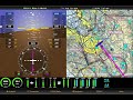
 wiesehahn
 Samarth1696
User Story
As a developer I can programmatically adjust the roll angle of the camera from 0 (level) to +/- 180° and I can programmatically adjust the pitch angle from 0° (looking down) to 180° (looking directly up) so that I can accurately represent the spatial orientation of the observer when displaying maps with 3D terrain.
Rationale
I am looking to use MapLibre in an aviation application to implement what is commonly know as "Synthetic Vision" - a feature which provides a virtual "view from the cockpit". To be able to accurately represent the this view, I need to be able to adjust the roll angle of the camera to match the roll angle of the airplane. You can see a similar system at a distinct roll angle here:
https://blog.foreflight.com/wp-content/uploads/2014/12/800x600-refined-terrain.png
From what I can find, the
transformCameraUpdatecallback currently allows programmatic control of bearing, center, elevation, pitch, and zoom (with pitch limited to 0° - 60°). Perhaps this could be extended to include the roll parameter and to accept pitch values from 0 (straight down) to 180 (straight up).It might also be useful to allow for all of these parameter to be incorporated into the parameter objects for
map.flyTo()andmap.easeTo(). The way the Synthetic Vision app works, a server feeds situation data (location, altitude, track, speed, etc.) over a WebSocket at between 10-20 Hz. The handler for the WebSocket moves the camera using a string of very short duration flyTo or easeTo operations. Adding the ability to update situational parameters directly would simplify the process.Impact
This won't have any real impact on users who only need a basic down-and-forward level view, but it will go a long way towards making MapLibre more useful for certain simulations, games, and situational awareness applications.