openstreetmap / iD

🆔 The easy-to-use OpenStreetMap editor in JavaScript.
https://www.openstreetmap.org/edit?editor=id
ISC License
3.34k stars 1.2k forks source link

Possibility to use more that one custom layer on ID editor #10055

Open dp7x opened 9 months ago

dp7x commented 9 months ago

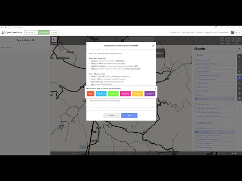
Hello I wanted to propose a new functionality that would be very useful for me when mapping, and I found this old post with my same idea. Are there any news about this ? It's not fundemental for me to save the custom layers in user's profile: it would be enough to me to have 2 or 3 custom layers options, to set up each time I log in pasting the URL. Then, during the mapping work, it woule let me to switch very fast from a layer to another. Thanks !

        More generally, it would be convenient if we could add as many custom layers as we wish: in France there are at least 3 rendering that might be useful at the same time (IGN aerial photos, cf #3420, Strava heatmap and [BANO](http://tile.openstreetmap.fr/~cquest/leaflet/bano.html)). 

It would mean a bit of UI reworking, but maybe something like that?

capture d ecran de 2017-02-22 19-07-22

Originally posted by @bagage in https://github.com/openstreetmap/iD/issues/2095#issuecomment-281755531

Asif-Sheriff commented 8 months ago

@dp7x Hey I have been working on this and have come up with a solution. Well its more of a band aid fix tbh. But the way it works is:

  1. You have multiple layers in the custom background section
  2. you can prefix the layer with '#' to not select it
  3. if a layer does not have the '#' prefix then it is selected

Here I have demonstrated how it works Screencast from 15-01-24 05:15:31 PM IST.webm

This way editors can quickly switch between layers rather than having to copy paste manually every time. Please lmk if you liked this implementation or if you have any suggestions.

dp7x commented 8 months ago

Hello @Asif-Sheriff This is a very good solution in my opinion, it is perfect for my needs. Maybe tomorrow a radio-button could be implemented to automatically activate/deactivate the # prefix, but really, your idea is already a very good solution. Please let me know when it can be ready to use !

Thank you very much !!!!!!

Asif-Sheriff commented 8 months ago

@dp7x I have created a PR now it has to be reviewed by an admin if they approve the changes the PR gets merged and the feature is added

dp7x commented 8 months ago

Thanks @Asif-Sheriff , this is great, thanks a lot for your help !!

Asif-Sheriff commented 8 months ago

The proposed solution was not accepted and I had to close the PR :( But dw i'm still working on this and hopefully I'll come up with a more robust solution like the one suggested in the picture above.

tordans commented 8 months ago

@Asif-Sheriff I provided an/my opinion. I did not reject anything nor do I have a role in this project to do so. - I am in favor of a more robust solution though.

Asif-Sheriff commented 8 months ago

@tordans I see.. admittedly there are issues with my previous implementation as you pointed out appreciate your input. working on a better fix for this

jjiglesiasg commented 8 months ago

At least two layers of custom data will be great, to not be jumping from one to other. Make it guys, please.... it's much needed...

Nekzuris commented 7 months ago

This is indeed a much needed feature.

dp7x commented 7 months ago

Hello guys, any news ? If no better solution is found, I think that @Asif-Sheriff proposal could be a good starting point to solve this issue... please !

sylvain-m commented 7 months ago

This is indeed a much needed feature.

+1

Nekzuris commented 6 months ago

While waiting for an implementation I found this extension that allows you to use Strava without the custom layer : https://chromewebstore.google.com/detail/id-strava-heatmap/eglbcifjafncknmpmnelckombmgddlco

dp7x commented 4 days ago

Hello guys. Since there haven't been any updates on this topic, I decided to develop a simple plugin to address this need while waiting for a definitive solution to be integrated into the standard version. The following video demonstrates how it works. Watch the video

Anyone who would like to help me test it, please contact me so we can ensure everything is in order before sharing it. Thank you!!

sylvain-m commented 4 days ago

I'm interested! You can contact me via the OpenStreetMap messaging system. Here is my profile: https://www.openstreetmap.org/user/Sylvain%20M

dp7x commented 4 days ago

Hello Sylvain, thanks for your fast reply. I've sent a message with the link to download from my OSM profile. Let me know !