osmandapp / OsmAnd

OsmAnd
https://osmand.net
Other
4.55k stars 1k forks source link

UK road shields #15817

Open poeticus opened 1 year ago

poeticus commented 1 year ago

A-roads in the UK tagged with 'highway=trunk' and 'highway=primary' are both labelled with the same green & yellow shield, whereas they are correctly rendered with different colours.

I believe that only those labelled 'trunk' should be shown with the green & yellow shield, and those as 'primary' with a black & white shield (as for secondary roads).

This would match the map to the signs drivers see on the roads.

See here for 'trunk roads' in the UK: https://wiki.openstreetmap.org/wiki/United_Kingdom_Trunk_Roads in particular: "Many UK OSM users follow the practice that all green-signed A routes (ie primary routes) are tagged highway=trunk, while black-and-white-signed A-roads (ie non-primary routes) are tagged highway=primary."

The same signage system appears to be in place in the Isle of Man, although I'm not sure about the Channel Islands. Both are currently shown the same as the UK.

poeticus commented 1 year ago

A bit more information.

OSM wiki on tagging UK roads: A-roads with primary status (signed yellow on green) - tag as 'trunk' A-roads with non-primary status (signed black on white) - tag as 'primary' https://wiki.openstreetmap.org/wiki/Roads_in_the_United_Kingdom

UK Government guidance on road signs. Search in page for 'primary'. Shows examples of primary route signs in green and, below that, non-primary route signs in black & white. https://www.gov.uk/guidance/the-highway-code/traffic-signs

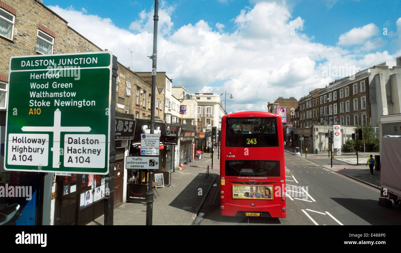
Here's a link to a photo of a junction in east London showing a sign for the non-primary A104 crossing the primary A10. https://c8.alamy.com/comp/E488P0/road-sign-for-a10-destinations-at-dalston-junction-243-bus-on-kingsland-E488P0.jpg

The screenshot below shows the current map display for that junction with both roads labelled in the same way (green & yellow).

DalstonA10

As green road signs in the UK are used exclusively on primary routes, maps should really reflect this.

poeticus commented 1 year ago

I've now checked the Highway Codes for the Isle of Man and for Jersey (the only one of the Channel Islands showing road numbers) and both confirm the design & colouring of directional signs to be the same as in the UK.

Some discrepancies are likely to result from this suggested change if a Primary Route A-road has not been tagged with 'trunk' as per the guidance in the OSM Wiki, but think that any such cases should really be dealt with by correcting the tagging. This may be an issue in Jersey where I think more of its roads are Primary Routes than currently indicated by their colour.

poeticus commented 1 year ago

In addition, I've just noticed that UK 'A-road motorways' are currently labelled with green shields, rather than with blue shields like the rest of the motorway network.

These roads, numbered in the form A1(M) (for example), are under motorway regulations (https://www.sabre-roads.org.uk/wiki/index.php?title=Category:A_Road_Motorways) and are signed as such (example of sign here: https://en.m.wikipedia.org/wiki/A1(M)_motorway).

They are tagged as motorways, and so are rendered on the map as such, but also should be shown with blue shields.

Looking at this has thrown up a related issue which would become more apparent with this suggested change.

The screenshot below shows the M25 / A1(M) intersection north of London. The A1(M) starts at the M25 and heads north. The A1 label north of the M25 and the A1(M) label south of the M25 are wrong.

A1M_1

Zooming in on the A1 label at the top of the screenshot shows this:

A1M_2

I assume this may be a tagging issue, however the online maps do not show the incorrect labels. I also checked to see how Magic Earth shows this area and it also does not show any incorrect labels. (As an aside, it labels the A1(M) in blue.)

I've noticed a similar issue with incorrect labels around the A38(M) / M6 junction north of Birmingham. There, when zooming in on one specific label, the actual label displayed (A38(M) or A38) changes with zoom level.

poeticus commented 1 year ago

A bit out of my depth here but thought it worth adding this further thought. Could the display of both 'A1' and 'A1(M)' on the same section of road be the result of picking up references from both Way and Relation elements?

Stretches of the A1 and A1(M) are part of the same continuous road with a Way reference of either 'A1' or 'A1(M)' depending on whether or not it is a motorway section, and a Relation reference which can apparently be the other road number.

This could also explain the incorrect labelling of the A74(M) in SW Scotland with both 'A74(M)' and 'M74'. The A74(M) forms the southern part of the motorway between the English border and Glasgow, the M74 the northern part. The entire length of motorway, however, has a Relation reference of M74. The screenshot shows a section of the A74(M).

A74M