 qgib
commented
11 years ago
qgib
commented
11 years ago Author Name: Regis Haubourg (@haubourg)
related to #15916
Closed qgib closed 3 years ago
qgib
commented
11 years ago Author Name: Regis Haubourg (@haubourg)
related to #15916
qgib
commented
11 years ago Author Name: Larry Shaffer (Larry Shaffer)
See https://github.com/qgis/QGIS/issues/15916#issuecomment-495666966 for update on related issue.
Please test with ee12df2 to see if your labels now can match MapServer's. Some comparison screen snaps again would be nice.
qgib
commented
11 years ago Author Name: Laurent Gasnier (Laurent Gasnier)
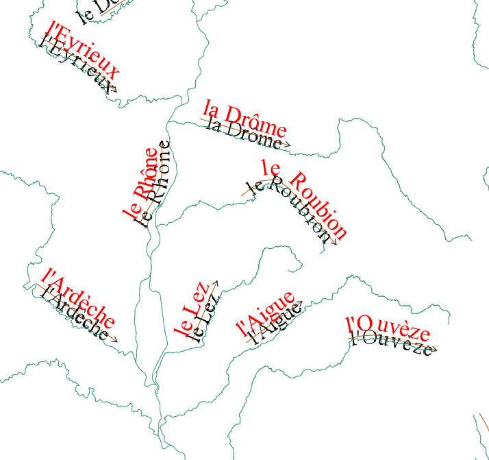
Hi Larry, Thanks, it's all right. The label "Le roubion" is drawn with outside angle of 40. See attached file test_anno_curv_roubion_outside_angle_40 (black labels from mapserver, red labels from qgis).
Second example: "Canal de Bourgogne" and "La Vingeanne" are drawn with outside angle of 30 and letter spacing of 150 mapunits. See attached file test_canal_de_bourgogne. For missing Qgis labels in this second example, see #15846
Seeing your example in https://github.com/qgis/QGIS/issues/15916#issuecomment-495666966, your proposal of character averaging is interesting.
qgib
commented
11 years ago Author Name: Regis Haubourg (@haubourg)
Hi Larry, confirmed here too, and really interested in the averaging solution to allow have readable labels for complex lines. See screenshot, that typically show big rivers, zoomed out, are the first to loose labeling, or to have overlapping characters.
qgib
commented
7 years ago Author Name: Giovanni Manghi (@gioman)
qgib
commented
7 years ago Author Name: Regis Haubourg (@haubourg)
Not in progress anymore, any funder welcome, QEP are all ready for those enhancements.
See attached screenshot test_anno_curv_roubion2.png: Black labels are drawn by a WMS Mapserver layer, red labels by QGIS.
The label "Le Roubion" is drawn only if MAXOVERLAPANGLE is set to 30 in .map file (with default value, it's not drawn). to Hi, In new labeling tool, it would be useful for the user to set the value of the max angle delta between letters (like MAXOVERLAPANGLE of Mapserver).
See attached screenshot test_anno_curv_roubion2.png: Black labels are drawn by a WMS Mapserver layer, red labels by QGIS.
The label "Le Roubion" is drawn only if MAXOVERLAPANGLE is set to 30 in .map file (with default value, it's not drawn).
 pjshelton
commented
3 years ago
pjshelton
commented
3 years ago @haubourg Did #29994 fix this particular problem? the labeling gui has allowed for adjusting the maximum angle between curved characters, both inside and outside now for a number of versions.
Can we call this closed?
@gioman?
 haubourg
commented
3 years ago
haubourg
commented
3 years ago Thanks for the cleanup! Yes we can close this.
Author Name: Laurent Gasnier (Laurent Gasnier) Original Redmine Issue: 6673
Redmine category:labelling
Hi, In new labeling tool, it would be useful for the user to set the value of the max angle delta between letters (like MAXOVERLAPANGLE of Mapserver).
See attached screenshot test_anno_curv_roubion2.png: Black labels are drawn by a WMS Mapserver layer, red labels by QGIS.
The label "Le Roubion" is drawn only if MAXOVERLAPANGLE is set to 30 in .map file (with default value, it's not drawn).
Related issue(s): #15916 (relates) Redmine related issue(s): 6763