 timelyportfolio
commented
7 years ago
timelyportfolio
commented
7 years ago That is very unfortunate. I will look into this problem. For reference, does it seem to be a precision issue? loss of points/nodes problem?
Closed Robinlovelace closed 6 years ago
timelyportfolio
commented
7 years ago That is very unfortunate. I will look into this problem. For reference, does it seem to be a precision issue? loss of points/nodes problem?
 Robinlovelace
commented
7 years ago
Robinlovelace
commented
7 years ago Trying to reproduce and save the result in a gif. Example of not reproducing it:

Robinlovelace
commented
7 years ago Update: I think I can reproduce the issue and suspect it's due to zooming. .gif example to follow...
Robinlovelace
commented
7 years ago Maybe panning and zooming in combination:
Robinlovelace
commented
7 years ago 
Robinlovelace
commented
7 years ago Update: I could reproduce the issue only panning at a single zoom level so now suspect it's more about panning.
Robinlovelace
commented
7 years ago Update: I think this issue only occurs at high zoom levels: that's why I cannot reproduce in the first .gif example. Just tried the same thing at a high zoom level and the result looks garbled.
 tim-salabim
commented
7 years ago
tim-salabim
commented
7 years ago Yes I can confirm. Whatever is Polygons drawn beyond a zoom level of about 15 seem garbled. Lines and points seems to be equally displaced. @timelyportfolio does this confirm your suspicion of a coordinate precision problem?
timelyportfolio
commented
7 years ago Strange. Here was my first test. I found a random lake in Canada and traced at zoom level 14 in Chrome. I then used editFeatures to try to trace at zoom level 16. Here is the result (note I got lazy and did not complete the trace).

library(sf)
library(mapview)
library(mapedit)

# at zoom level 14 create a polygon with mapedit
#   to use for testing
p1 <- structure(list(structure(list(structure(c(-76.1935, -76.1922,
  -76.191, -76.1904, -76.1902, -76.19, -76.1891, -76.1876, -76.1864,
  -76.1862, -76.1862, -76.1862, -76.1857, -76.1848, -76.1834, -76.1819,
  -76.1806, -76.1783, -76.1774, -76.1764, -76.1756, -76.1745, -76.1728,
  -76.1722, -76.1712, -76.1699, -76.1692, -76.168, -76.1662, -76.1657,
  -76.1647, -76.1638, -76.1627, -76.1616, -76.1608, -76.1596, -76.1595,
  -76.1595, -76.1586, -76.1573, -76.1574, -76.1568, -76.1569, -76.1569,
  -76.156, -76.1563, -76.1566, -76.1572, -76.1583, -76.1589, -76.16,
  -76.161, -76.162, -76.1631, -76.1639, -76.1651, -76.167, -76.1677,
  -76.1686, -76.1691, -76.1696, -76.1696, -76.1698, -76.1705, -76.1709,
  -76.1712, -76.1711, -76.1715, -76.1743, -76.1777, -76.1803, -76.1813,
  -76.182, -76.1828, -76.1844, -76.186, -76.1875, -76.1891, -76.1904,
  -76.1918, -76.1936, -76.1949, -76.1959, -76.1968, -76.1971, -76.1976,
  -76.1975, -76.197, -76.1962, -76.1956, -76.1951, -76.1943, -76.1935,
  45.1188, 45.1186, 45.1187, 45.1192, 45.12, 45.1205, 45.1213,
  45.122, 45.1224, 45.1232, 45.1239, 45.1244, 45.1249, 45.1255,
  45.1259, 45.126, 45.1257, 45.1256, 45.126, 45.1262, 45.1262,
  45.1259, 45.1259, 45.1257, 45.1254, 45.1249, 45.1245, 45.1248,
  45.1244, 45.1239, 45.1236, 45.1234, 45.1238, 45.1236, 45.1232,
  45.1233, 45.1242, 45.1248, 45.1248, 45.1248, 45.1237, 45.1229,
  45.1224, 45.121, 45.1198, 45.1187, 45.1179, 45.1174, 45.1178,
  45.1166, 45.1156, 45.1146, 45.1141, 45.1135, 45.1133, 45.1127,
  45.1124, 45.1128, 45.1131, 45.1138, 45.1144, 45.1156, 45.1161,
  45.1164, 45.1151, 45.1135, 45.1124, 45.1119, 45.1116, 45.1118,
  45.1114, 45.1121, 45.1126, 45.1128, 45.1131, 45.1131, 45.1136,
  45.1138, 45.1141, 45.1141, 45.1141, 45.1141, 45.1144, 45.1146,
  45.1151, 45.1157, 45.1165, 45.1171, 45.1176, 45.1181, 45.1182,
  45.1186, 45.1188), .Dim = c(93L, 2L))), class = c("XY", "POLYGON",
  "sfg"))), n_empty = 0L, precision = 0, class = c("sfc_POLYGON",
  "sfc"), bbox = structure(c(-76.1976, 45.1114, -76.156, 45.1262
  ), .Names = c("xmin", "ymin", "xmax", "ymax"), class = "bbox"), crs = structure(list(
  epsg = 4326L, proj4string = "+proj=longlat +datum=WGS84 +no_defs"), .Names = c("epsg",
  "proj4string"), class = "crs"))

editFeatures(st_sf(p1))I suspected the issue might be RStudio Viewer, but this test seems to yield expected results.
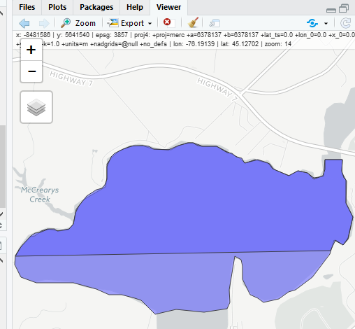
Then, I thought maybe the error is caused by zooming to different levels during the draw, but everything seemed fine.
I think I finally experienced the problem when I did editFeatures(p1) and zoomed to level 18 to edit the contour. My edit was much closer to the creek or offshoot than what appears below, so I will classify this as a replication.
tim-salabim
commented
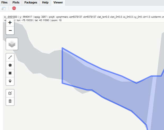
7 years ago Here's an addition I drew to @timelyportfolio 's example using tst = editMap(mapview(p1)). I did the drawing in RStudio viewer at zoom level 17. I tried to follow @timelyportfolio 's outline as close as possible (i.e. replicate his vertices) for a small portion outside the lake. It turns out that I apparently did a very good job as all vertices seem to be topologically identical :-)
tst = structure(list(X_leaflet_id = 87L, feature_type = "polygon",
    geometry = structure(list(structure(list(structure(c(-76.1705,
    -76.1698, -76.1696, -76.1696, -76.171, -76.1709, -76.1705,
    45.1164, 45.1161, 45.1156, 45.1144, 45.1144, 45.1151, 45.1164
    ), .Dim = c(7L, 2L))), class = c("XY", "POLYGON", "sfg"))), n_empty = 0L, precision = 0, class = c("sfc_POLYGON",
    "sfc"), bbox = structure(c(-76.171, 45.1144, -76.1696, 45.1164
    ), .Names = c("xmin", "ymin", "xmax", "ymax"), class = "bbox"), crs = structure(list(
        epsg = 4326L, proj4string = "+proj=longlat +datum=WGS84 +no_defs"), .Names = c("epsg",
    "proj4string"), class = "crs"))), .Names = c("X_leaflet_id",
"feature_type", "geometry"), row.names = 1L, sf_column = "geometry", agr = structure(c(NA_integer_,
NA_integer_), class = "factor", .Label = c("constant", "aggregate",
"identity"), .Names = c("X_leaflet_id", "feature_type")), class = c("sf",
"data.frame"))

mapview(p1) + tst
Robinlovelace
commented
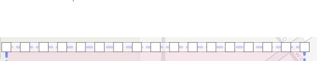
7 years ago Here are some more experiments.
Reproducible example (sorry about all the pkgs!) to geocode a building just south of Willow Terrace at Zoom Level 18:

Slightly garbled output:

Robinlovelace
commented
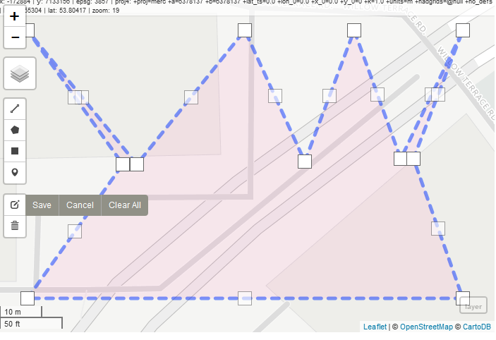
7 years ago And taking more care (zoom level: 19 in Firefox):

Robinlovelace
commented
7 years ago The result makes me think it's a precision/snapping issue:

Robinlovelace
commented
7 years ago Please try to reproduce this simple example with the code below:
library(sf)
library(mapview)
library(mapedit)
library(tmaptools)
library(stplanr)
b = tmaptools::bb("University of Leeds")
p = bb2poly(b)
sp::proj4string(p) = "+init=epsg:4326"
m = mapview(p)
p = editMap(m@map)
plot(p$finished)@Robinlovelace, I used your example polygon with editFeatures(st_as_sf(p)) to try a couple of things.
I thought maybe instead of precision we might be losing some nodes. So I edited the polygon and added nodes such that they filled the entire top edge.
But this worked as expected.
Next I tested precision as shown below.
This test failed with correct number of nodes but incorrect precision

timelyportfolio
commented
7 years ago Then I did this

and got

I used recorder = TRUE and the recorded feature matches the final sf, so the loss of precision is occurring in JavaScript. I think the newest Leaflet.draw still works in the older Leaflet. I'll try later today to use the newest Leaflet.draw to see if this might have been solved.
Robinlovelace
commented
7 years ago That is a great final demo of what is going on - look forward to hearing of how upstream developments can feed into the solution. Any JS people we can ask to find out why this dramatic loss of precision is happening? It sounds like you're on it in any case, many thanks for reproducing and pinning down the issue so quick.
timelyportfolio
commented
7 years ago I'll try the upgraded Leaflet.draw and also inspect the JavaScript GeoJSON tonight to find the source of the issue. At least, I feel like now we have an easily replicable example :)
 mdsumner
commented
7 years ago
mdsumner
commented
7 years ago This is such a great thread, so much useful information!
timelyportfolio
commented
6 years ago @Robinlovelace @tim-salabim through https://github.com/codeofsumit/leaflet.pm/pull/306#issuecomment-399096183, I just discovered https://github.com/Leaflet/Leaflet/pull/5444 which should solve or partially solve this issue. I will test.
timelyportfolio
commented
6 years ago @tim-salabim Leaflet > 1.0 changed geojson precision to 6 digits as described above. However, after some thorough tracing, I discovered the the st_as_sfc.geolist use of jsonlite::toJSON clipped to 4 digits which is the jsonlite default. I have changed to 6 to match Leaflet. Based on tests (shown below), this seems to be good enough to zoom levels 17, 18, and 19.
@Robinlovelace If possible, testing would be extremely helpful. Thanks!!
library(sf)
library(mapview)
library(mapedit)

x <- editMap(mapview())
mapview(x$finished)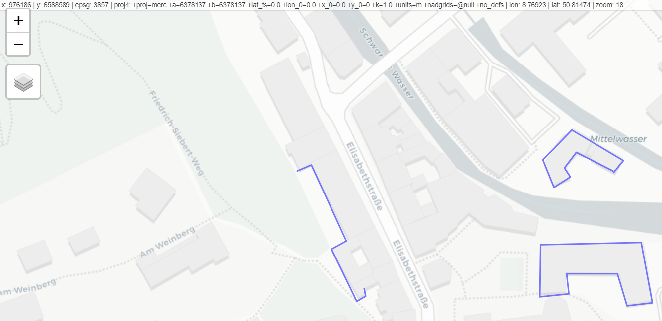
Is 6 enough?
Does the precision need to be an argument with 6 as default?
Robinlovelace
commented
6 years ago @timelyportfolio I'm on the case :+1:
Robinlovelace
commented
6 years ago @timelyportfolio what do I need to install to get the latest functionality? Just tried it and the spatial resolution issue seems to remain:

timelyportfolio
commented
6 years ago @Robinlovelace wow, that was quick and thanks. I think you will just need the newest (CRAN) leaflet and leaflet.extras along with devtools::install_github("timelyportfolio/mapedit"). I have not merged the pull at r-spatial yet.
tim-salabim
commented
6 years ago @timelyportfolio thanks so much! Awesome that it turned out to be such an easy fix. I tried various zoom levels and it seems that we loose precision at zoom 26.
IIUC, leaflet has precision 6 and that cannot be increased? Have you tried this with digits = NA in toJSON as the help states
max number of decimal digits to print for numeric values. Use I() to specify significant digits. Use NA for max precision.
which should give back the precision of what has been drawn (i.e. 6 in new leaflet), right?
Re having an argument to pass precision, I am undecided. I think most people would favor higher precision, but we cannot have more than 6, however, there may be instances where people only wanna draw at 3 or 4 digit precision, e.g. to ensure that drawn features fit into existing geometries... I guess it's easy enough to include an argument, so why not give the power to the people.
Oh, and I think we should add a link to [Wikipadia](https://en.wikipedia.org/wiki/Decimal_degrees] on this topic, as it has a nice overview on the digit -> accuracy issue (including differences at different lattitudes).
Robinlovelace
commented
6 years ago Confirmed: it's working! I consider this issue closed now (hence closing). I think setting the default precision to 6 is fine. Not sure how many people will want less (they could always snap after the event) but the idea of adding a precision argument sounds good. I think it's worth saying how that translates to spatial scale, e.g. objects created with mapedit have a spatial resolution of 1 millionth of a degree (0.000001), which translates to roughly 10 cm at the equator (see https://en.wikipedia.org/wiki/Decimal_degrees).
Robinlovelace
commented
6 years ago Gratuitous gif showing it action!

timelyportfolio
commented
6 years ago @tim-salabim I will explore what options we have available on the leaflet js side. Then we can decide how we would like to proceed with potential precision argument. Unfortunately, adding this will likely require a change to R leaflet or leaflet-extras, which might delay rapid incoporation. I like the idea of jsonlite NA argument which would mean we don't need to chage in future if we go with an argument.
@Robinlovelace Thanks so much for bringing this up. Sorry it took so long. I'm going to reopen for just a bit longer while we iterate through various combinations.
Robinlovelace
commented
6 years ago OK great, many thanks for the fix, opening the issue was the easy part! To re-iterate I think a default precision of 6 dp would be fine. Should be simpler on the coding side also. But will defer to your judgement on this - seems to have worked so far to contribute key components to an amazing package!
timelyportfolio
commented
6 years ago @tim-salabim your NA suggestion worked great and that way if we can get a precision argument in leaflet/leaflet.extras then we will not need to change. I worked through the code in leaflet.extras and adding a precision argument is fairly straightforward but unfortunately fairly instrusive as well. I think for now we should stick with what we have. I'll start a new issue over on leaflet.extras since that decision is more out of our hands.
Also I just realized that I didn't answer your question. leaflet > 1.1 can go to higher or lower precision, but the default is now 6.
Thanks everyone!!
Thanks for an awesome package.
I've used it for work and all went well until I looked at the object that I created.
I definitely saved a polygon representing the roof space of this site plan but
plot(r_new2$finished$geometry)came out like this (it should be a nice curve following the roof which was what I drew):Any ideas why? Have others reported this - can retry if I discover what I'm doing wrong (I did some re-editing).
Here's some partitially reproducible code, which geo-referenced the raster - that was very useful!
https://github.com/Robinlovelace/geocompr/pull/77