 Dassem
commented
11 years ago
Dassem
commented
11 years ago Idea base: The map below is very balanced.
http://i.imgur.com/azR5vWS.jpg
Keep in mind that the above image is not ours and so cannot be used for the map in any form.
Closed BlockFortress closed 11 years ago
Dassem
commented
11 years ago Idea base: The map below is very balanced.
http://i.imgur.com/azR5vWS.jpg
Keep in mind that the above image is not ours and so cannot be used for the map in any form.
 Leopere
commented
11 years ago
Leopere
commented
11 years ago I would be interested in possibly contributing in this project maybe I could set up a teamviewer machine on my end like how soren and diage do their coding. Then we could both work on the map and should get something done by the end of the week if not sooner.
Dassem
commented
11 years ago Here is a collection of custom trees that can be used in a custom World Painter brush. http://www.planetminecraft.com/project/native-trees-of-europe-template-repository-1779952/
Dassem
commented
11 years ago I've been playing around with Campaign Cartographer 3 and here is a result:
(This is just for a reference for World Painting)

My lakes accidently got deleted D:
Leopere
commented
11 years ago We should make a list of things like biomes that we would like and possibly describe how it is that we want the biomes to be. do we want an endless map or at the end of the map would we like void so the map cant grow past its borders etc.
We have 4 main classes at the moment. do we just want a biome for each and then on expansions we will add more biomes?
What sorts of stuff are we looking for I'd like to get some of this stuff figured out so that the new map can feel a bit more guided/well informed.
Leopere
commented
11 years ago http://i.imgur.com/SqzU5DG.png < @DarkProSpect generated from this map layout suggested and created by @BlockFortress > http://i.imgur.com/tu6kgMQ.png
Initial Concept / style suggested by @DarkProSpect > http://i.imgur.com/MSPTVMk.png .
Suggestion from @justjeff94 http://lparchive.org/Divinity-II-The-Dragon-Knight-Saga/Update%2006/2-Map01.jpg
@Grimwraith should take a look at the suggested map by @DarkProSpect and concidder importing that into WorldPainter once we come up with a final revision for map generation concidderation.
Leopere
commented
11 years ago  Very Rough in Alpha map with some points drawn up on how it needs to function Discussed and Drawn by @diage and @chamunks > http://puu.sh/1YZtO
Cleaned up version interpreted and re-iterated by chamunks > http://puu.sh/1Z4NW and explained in a simplified form.

 CandleD
commented
11 years ago
CandleD
commented
11 years ago Remember, the edges of the map need to be drop offs into the void, otherwise, I need to re-write the entire lore.
 DarkProSpect
commented
11 years ago
DarkProSpect
commented
11 years ago here is one of the things i did in morning before all planing but i wwould like to keep it for record http://i.imgur.com/GQybFzp.jpg

Dassem
commented
11 years ago https://github.com/Wickth/TerrainControl/wiki/Creating-a-world-from-an-image We can quite easily make a map with TerrainControl and then finish it with WorldPainter.
@DarkProSpect You should pay attention here.
DarkProSpect
commented
11 years ago the map is 15 000 x 15 000 px. so far i have splited in in regions and itsready for importing on world painters and other magical things what makes dreams come true. If anyone need my help or edit the map again, i can be found on skype - kroplis_bui (Sometimes i sleep...sometimes)

DarkProSpect
commented
11 years ago Update:
Something something lore - water fall in void around map borders. map edit request after candle.
I'm sorry that im so pessimistic about descriptions, I would prefer if i would get exact thought on some paper scrap of what peoples would like to see on map.
I also would like to stay out of all kind of drama like - whose in charge - he said,she said and in the end im the blamed one. I would like to lead by moto - we are team and we will work as one.
01:03:03 "Candle": How about this, we close off that bay and then make the blue outsides of the map void 01:09:21 "ProSpect": then its done. I making an additional island from haleras side till solari clifs.
CandleD
commented
11 years ago Well, now I suppose the area that is Black should be the abyss. Aside from the bay in the middle, that is.
Leopere
commented
11 years ago We could add bits of ocean that just punch through to void on the outside of the land maybe to keep people from just immediately falling into the void? I kind of like the idea of the edge of the map being not a straight line but its going to be tricky because world painter is going to want to set bedrock at y:0
@DarkProSpect I wouldn't worry too much about the politics ultimately its Candle Block and Grim who you have to communicate with. Those are the four people who are working on the Map Team.
I just tried appointing you into this because you seemed suited for the matter.
Is @Grimwraith watching this thread? He should be.
Also someone should ping @sorren (who still is not in this github for some reason.)
Leopere
commented
11 years ago Also beautifully done on the greyscale @DarkProSpect that should import beautifully into WP
Leopere
commented
11 years ago I'm going to tag @Soren025 in this he needs to look into and post some information on converting mcedit(WorldEdit Default) schematics into BO2 files needed for Terrain Control.
 diage
commented
11 years ago
diage
commented
11 years ago @chamunks I'm pretty confused, did the discussion we had just get scrapped or what? I suppose it doesn't matter if it did, I am just a coder stepping a little outside of my domain. Just curious mostly.
Leopere
commented
11 years ago @diage I have no idea what I'm taking about obviously nvm lol
Leopere
commented
11 years ago I've been afk for over a day that seems to make a huge difference here sometimes.
 Soren025
commented
11 years ago
Soren025
commented
11 years ago http://www.worldpainter.net/trac/wiki/CustomObjects
it appears bo2 files are compatible with world painter.
no luck in finding a working mcedit to bo2 converter, from what I read massive craft has one but they don't share it.
Soren025
commented
11 years ago https://github.com/MassiveCraft/s2b
here it is, it is aperently written in ruby so have fun with that
also here is how they export them aperently
Soren025
commented
11 years ago https://github.com/MassiveCraft https://github.com/MassiveCraft/mcore
looks like we will need to sift mcore also
 TobyShaw
commented
11 years ago
TobyShaw
commented
11 years ago I got the massivecraft script to work, and can convert .schematics into .bo2s I'm using BBOB in order to edit the properties. : http://faskerstudio.com/minecraft/BBOB/downloads/BBOB-v0.7.2.zip
This basically means we can generate villages, custom trees, coral reefs, shipwrecks, bushes, wheat fields, through WorldPainter across the entire map. For larger schematics (main cities), we can simply use the .schematic format and determine its paste position by its top-right corner.
TobyShaw
commented
11 years ago Unfortunately WorldPainter doesn't support a couple of properties which would make it infinitely more useful (such as filling underneath the schematic), although we could ask them to add support for it.
Soren025
commented
11 years ago  BROWN - mountions
YELLOW -desert
BLUES - rivers and warer
ORANGE - platues
LIGHT GREEN - plains
GREEN - forest/jungle
TEAL - swampy land
BROWN - mountions
YELLOW -desert
BLUES - rivers and warer
ORANGE - platues
LIGHT GREEN - plains
GREEN - forest/jungle
TEAL - swampy land
RED CROSS- solari capital ORANGE CROSS - brecar capital GREYISH CROSS - thyrune capital LIGHT BLUE CROSS - haellera capital
PURE BACK AREAS UN EDITED - void
diage
commented
11 years ago That is our compromise to block. It still gets through the concepts I was hoping to see while making use the layout that others desire.
So, lets start from afar and work to specifics.
The large mark through the center which is brown, represents a cliff that follows that interior edge and then keeps heading north onto the main land following the line. This entire cliff makes the map almost twice as large and separates the map with something that could be completely awe-inspiring. The left side of the mountain houses the brecar and the solari. The brown on that left side is a large mountain range to which houses the brecar and a complex system of ancient water ways. Along the far left side, chunks of land float that separates where mountains used to be connected to mountains. As they die down towards the north, the terrain gives way to a marvelously carved plateau system. This system houses the solari and their patrons. Rivers can slide their way through and back towards the north where they can fall into the void. This system can be looked at as almost a system of massive valleys or a system of plateaus. Just depends on your perspective. Coddled and sheltered by the mountains is that yellowish area which represents a desert. Within the the mountains is a large lake that spawns the massive water system that can be followed throughout the entire map. As the desert meets the river, a plains is born. Grassy plains follow the river all the way until it hits the cliff. Standing along the cliff on the north side and looking east you see a monstrous jungle full of huge trees house the Thyruun. Much like you are in South America standing on a cliff looking at the jungle, you stand on the ledge watching the home of the Thyruun. As this slides around further to the South East, the jungle turns to swamp. The teal is all swamp land and this slowly turns into a moderately deep water system. Right along the edge of the land lies what is essentially a massive drop down into a crater. The home of the Haellera sit on the edge of this and are privy to a stunning view of a niagra falls on steroids around them. The entire center dark blue area is a special underwater biome that sits at a lower level than the lighter blue above it.
One more thing, this is a maybe, but I think it would be cool. Over top of the water coming from the cliff side could be islands floating. Much like ours is floating over the void, islands can be floating over the massive crater.
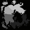
Leopere
commented
11 years ago @diage the map you guys are looking at in greyscale is the hight map. The lighter the grey the higher on the y axis the elevation is meant to be.
With the black being space for ocean bed.
"One more thing, this is a maybe, but I think it would be cool. Over top of the water coming from the cliff side could be islands floating. Much like ours is floating over the void, islands can be floating over the massive crater."
This is entirely possible using schematics for sky islands that @BlockFortress could make into schematics that toby grim and I can install using world painter.
I like where you're going with this description though but please try to make it flow with the hight map not against it I've not seen any rivers that flow up stream. But keep up the good concept work this is exactly what we need for the final phase before the actual world painter section.
Soren025
commented
11 years ago  I have another map concept that will also solve all of our problems of map design. The world is broken right? so lets make it broken, scatter the map with many large land masses that over the years of exploration members of the 4 races have linked various networks of these masses with short range portals.
The following are the pros of this: 1: Completely eliminates arguing of ware the capitals should be because with this system it doesn't really matter what matters more is how we set up the portal links between islands
2: Alow for free design in the creation of any obscure island and allowing it to work, It makes total sense for an island to be a desert and linked to it is an island that is all of a sudden jungle. It is logical to say that the jungle island retained its moisture and water and thus thrived with plant life while the desert island lost all of its water in the great ruin and became a desert.
3: Creates natural choke points throughout the world. The portals I see being key points of camps and gangs. design it as such that one must send a scout through a portal to check if it is safe to go through, if it is not design it as such that 90% of the time there will be an alternate root to your destination through a scenic link path. 90% meaning we gota have those dead end links, ya just gota.
4: Makes any expansion we want rational, simply state that explorers have found a new land mass and have connected a new portal link to it
5: I have heard that candle wants the haellera to have their own void island, with this system. she can very easily.
6: For those you who noticed, yes this concept has Eve Online influences. Eve is a game that has lasted the test of time and is still going strong. picking apart some of their concepts and making them our own I feel is a good idea.
Soren025
commented
11 years ago  Here is the same map concept but correct to the grey scale height map pro made by request of chemunks
Soren025
commented
11 years ago  Here is an image of an eve map, solar systems are linked by jump gates creating a network that players can traverse. This is to strengthen my Idea for instead of one large island, to have many small and large land masses connected with portals.
try this link with another view of the concept if the image is too small http://evemaps.dotlan.net/map/The_Forge
EDIT: Also note ware I am going with this idea is that each capital would be separated by some number of island portal links meaning each capital would have their own island. As well as each race having their own little cluster of island that they deem their territory.
Having islands like this as an added bonus would work well for factional warfare as we can clearly denote area control as nodes or islands.
another interesting part about doing the portal linked islands is that with varying sizes one might be able to build an entire town on one small/medium sized island and claim that island as their own.
other interesting features could be that sense these portals would be defined by the staff, players cant destroy or create their own, only camp them and stop move flow through them that way. However using the idea of scheduled transport brought up at one point(not sure how far that spread yet), players could make their own sudo links via use of perhaps air ship docks or the town contracted way point links. It greatly increases the value of your island having things like this when your only or all of your portal link off the island is being camped by a group.
TobyShaw
commented
11 years ago Obviously you're trying to sell the idea, but I think its important somebody mentions the cons to this idea.
Being forced into an area where there is a high probability of PvP could get annoying for anyone merely wanting to go into a different area to collect a different kind of wood.
Another smaller issue is that in order to have the same landmass shown in the mainland idea, we would have to roughly double the size of the map in order to fit in the ocean between.
I'll update if I think of more, but I think those 2 are the main ones.
diage
commented
11 years ago @chamunks That is why I called it a compromise :). I overrode some of the initial logic built into it with our own while keeping a large portion of the constraints. It is the very definition of a compromise. But, although I like the orientation a little less, if you must impose an arbitrary height map you can use sorens second drawing. But I see no reason to arbitrarily stick to that just because its already painted those particular grey colors.
@Soren025 Sorry, but that idea is not best used here imo. That is something that can be used elsewhere
@TobyShaw I don't really know to whom you are talking. I assume soren's idea about the multiple land masses. To that, I would say that is kind of the point, separating goods to local markets would also improve the need for trade and regional economies.
Added: And btw, the gray scale was in no way an evident height map. So I doubt that most people already have a conception that the map is structured around that current height "setting"
Soren025
commented
11 years ago  expanded map concept of solid land mass
Diage mentioned to me that he feels we should still have a single solid land mass but link those islands seen above and many more in a similar way with my idea using the portal links to link new land masses for expanding the landscape.
diage
commented
11 years ago It's an ok iteration, I personally am still the most fond of the first one. This one here though create some interesting features. The left side seems to be the "civilized" side whereas the right is mostly (initially) uninhabited. Making certain there are avenues to get to the desert from both the south and the north, that would be alright and create an interesting space for expansion. But, still prefer the first :)
CandleD
commented
11 years ago I agree with the latest map's layout. As I said in one of the other issues, I would like one of the larger islands to be reserved for a future event.
Soren025
commented
11 years ago  @diage
shifted the forest like you said
@diage
shifted the forest like you said
Leopere
commented
11 years ago Looks like progress is being made here this is good finally with some debate its starting to look like this issue may come to a close and we can move forward into map generation. Can we all agree on @Soren025's last posted map https://github.com/chamunks/FallenFates/issues/47#issuecomment-13537905 if we can we should close this ticket and consider it a final revision.
Leopere
commented
11 years ago Ok im working on starting the map generation now.
diage
commented
11 years ago Ok I am not working on starting the map generation now.
Leopere
commented
11 years ago  This seem acceptable enough?
Leopere
commented
11 years ago  Alternate ocean / border concept the edge of the blue would drop directly off into the void somehow.
This one is Mooted.
 king0fblad3s
commented
11 years ago
king0fblad3s
commented
11 years ago I like the ocean instead of straight void
Dassem
commented
11 years ago http://www.planetminecraft.com/project/native-trees-of-europe-template-repository-1779952/ Custom Trees we can use.
 BlockFortress
commented
11 years ago
BlockFortress
commented
11 years ago 
So here is the map with basic heights and rivers included. You can also see the additions of the Solari plateaus and Thyruun canyons. This also has the additions of bodies of water connecting the islands sitting off the mainland. Not all the islands are connected per Candles request.
The only other major feature is the Brecar mountain range that most of the water flows off. It is quite a large volume of water, so what I was thinking is making is kind of a storm mountain range. So it's constantly raining/snowing on the peaks with lightning shooting down everywhere. Not only would this disallow for the Solari to gain easy access to the brecar BUT it would also make sense as to why there is so much water.

Soren025
commented
11 years ago @BlockFortress one small detail missing, the platu area should be minimum yellow or orange as the cliff face along the north western part of the ocean, it was there to make it difficult to just go straight from solari to haellera and vice versa. as it seems to be still in place like that for the thyrune and brecar.
it was what created that sudo wheal effect that I remember candle or you wanting.
Also im not sure but it seems like you shaved off part of the mountioney desert a bit on the eastern end of the map, the swamp looks so dominant over the map now, almost making it look like half the map belongs to the haellera.
as for the water Im fine with this setup, somewhat. as long as it makes sense as to how water can just flow off the edge endlessly and never run out
but ya my only gripe as a list is the following: -Solari platu floor to low -the clif face separating solari from haellera is no longer present -the swamp/ocean looks to dominant on the map -and just noticed some rivers seem to be flowing upwards, is the body of water near brecar the source of them? -also is the thyrune capital in a swamp? -one more thing, the transition from desert to swamp should be more sevear. the Idea in my map was to have it connect by cave networks and underground waterways not a slope.
BlockFortress
commented
11 years ago To make it a little more clear,

Rivers on top of the land with no apparent water source are spaced further apart. It is just runoff from the land itself collecting together. I dislike the idea of having a wall between the solari and the thryuun. Basically because players will just block jump up it. It will serve next to no purpose. If you wanted it to be quite high you would have to raise the level of the entire landscape around the brecar area as well. Meaning that the mountains would be stumpy. 256 is still small. Especially if the ocean top sits at y70 or so. The only addition that I see fit would be a mountain range dividing the swamp/jungle with the desert.
BlockFortress
commented
11 years ago Ok changes made per request of diage and soren.

Soren025
commented
11 years ago @BlockFortress your on the right track you have blurred the transition between the desert, mountions, and swamp. and gave the possibility to incite desions among players, such as "should I risk traveling through the narrow mountion pass into the desert or should I traverse the natural watter way cave system underneath.
both paths provide advantages and disadvantages for pvp raids and travel.
this dynamic still lacks for the solari and thyrune and their borders with the haellera and each other.
create land features that cause those dynamic choices of what to do, what path to take. speed of travel vs risk of travel. those locations that will scream ambush. not just one big open field that anyone can just pick any arbitrary path and they are safe.
BlockFortress
commented
11 years ago Closing and moving discussion to https://github.com/chamunks/FallenFates/issues/65
Leopere
commented
11 years ago Reopened due to this is still a relevant issue not to be closed due to bi-polarbears
Generic issue. Please use this to update us. Thank you grimy-poo