 PreethikaSelvam
commented
1 month ago
PreethikaSelvam
commented
1 month ago Hi @aike1202,
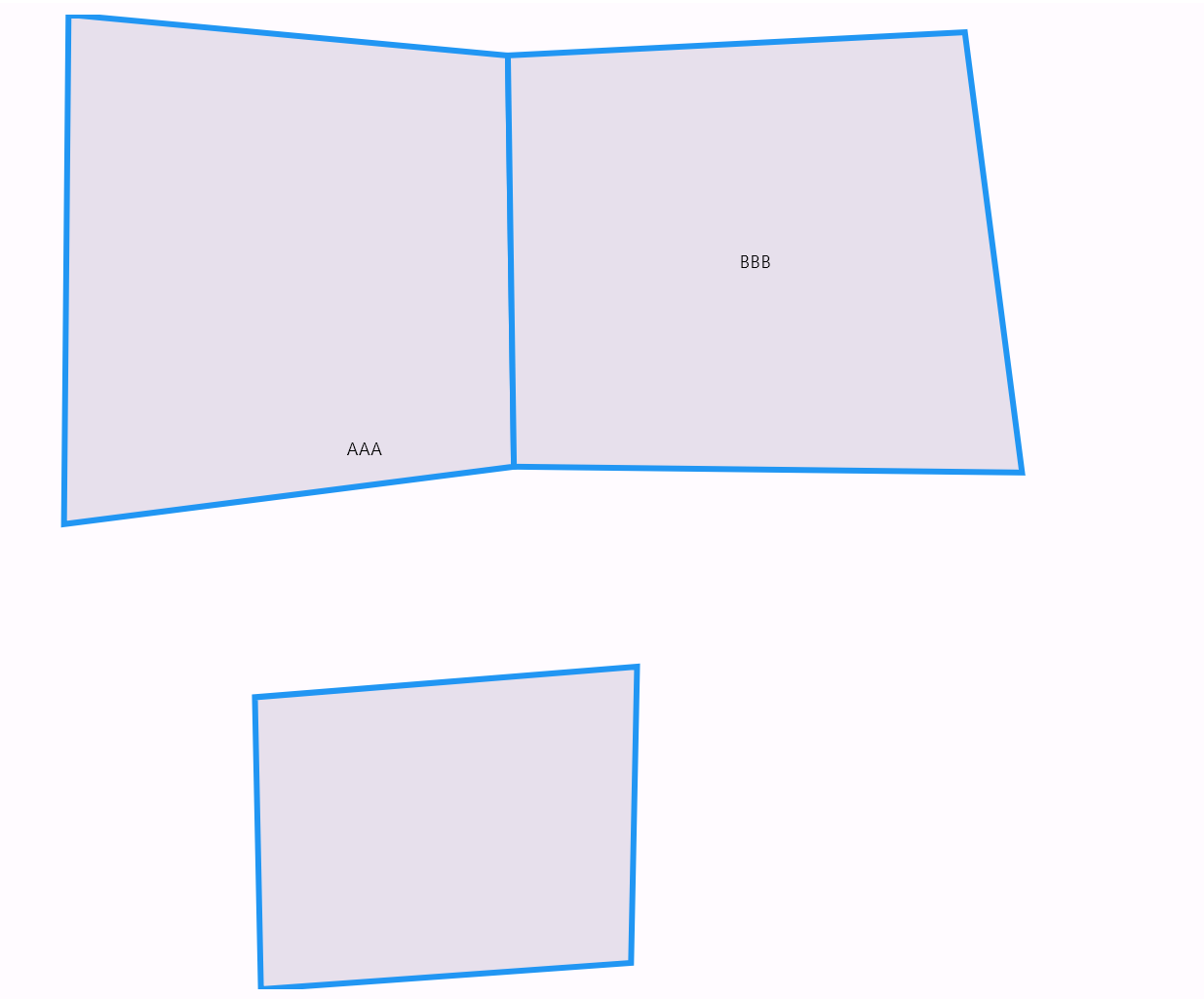
Query: When I set showDataLabels true and pass shapeDataField in MapShapeSource, the area inside the Feature BBB is not visible.
We have analyzed your query and found that you are loading the "AAA" JSON data first, followed by the "BBB" JSON data. Based on the JSON, the "BBB" data is being drawn on top of the "AAA" data. We suggest loading the "BBB" JSON data first, followed by the "AAA" data. This will ensure that the "BBB" data is drawn first, allowing the "AAA" data to be drawn on top of it and preventing overlapping issues. We have shared a modified JSON file and output for your reference.
Output Screenshot:
Please let us know if you need any further assistance.
Regards,
Preethika Selvam. bd580689.zip
 aike1202
Bug description
issue when use geogson has a ring inside MultiPolygon Feature
Steps to reproduce
then I tyr run on window find that when mouse hover the Feature AAA the area in Feature BBB appear agin ,then I thout it minght the problem off Feature BBB,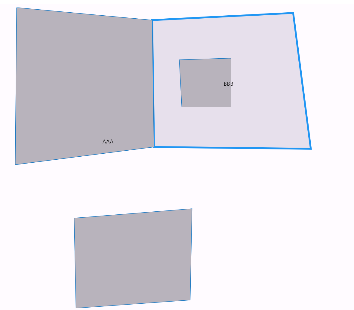 not hover
then i removed the Feature AAA ,it is not show a hole in BBB I think this is the issue come from
here is my original Feature BBB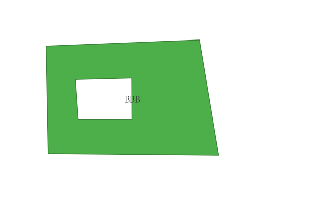
Code sample
Code sample
```dart import 'package:flutter/material.dart'; import 'package:syncfusion_flutter_maps/maps.dart'; class MapPage extends StatefulWidget { const MapPage({super.key}); @override StateScreenshots or Video
Screenshots / Video demonstration
Stack Traces
Stack Traces
```dart [Add the Stack Traces here] ```On which target platforms have you observed this bug?
Android, Web, Windows
Flutter Doctor output
Doctor output
```console Flutter assets will be downloaded from https://storage.flutter-io.cn. Make sure you trust this source! [√] Flutter (Channel stable, 3.19.0, on Microsoft Windows [版本 10.0.22000.2538], locale zh-CN) • Flutter version 3.19.0 on channel stable at C:\Users\Aike\dev\flutter • Upstream repository https://github.com/flutter/flutter.git • Framework revision bae5e49bc2 (9 weeks ago), 2024-02-13 17:46:18 -0800 • Engine revision 04817c99c9 • Dart version 3.3.0 • DevTools version 2.31.1 • Pub download mirror https://pub.flutter-io.cn • Flutter download mirror https://storage.flutter-io.cn [√] Windows Version (Installed version of Windows is version 10 or higher) [√] Android toolchain - develop for Android devices (Android SDK version 34.0.0) • Android SDK at C:\Users\Aike\AppData\Local\Android\sdk • Platform android-34, build-tools 34.0.0 • Java binary at: C:\Program Files\Android\Android Studio1\jbr\bin\java • Java version OpenJDK Runtime Environment (build 17.0.7+0-b2043.56-10550314) • All Android licenses accepted. [√] Chrome - develop for the web • Chrome at C:\Program Files\Google\Chrome\Application\chrome.exe [√] Visual Studio - develop Windows apps (Visual Studio Professional 2022 17.9.5) • Visual Studio at D:\Program Files\Microsoft Visual Studio\2022\Professional • Visual Studio Professional 2022 version 17.9.34723.18 • Windows 10 SDK version 10.0.22621.0 [√] Android Studio (version 2023.1) • Android Studio at C:\Program Files\Android\Android Studio1 • Flutter plugin can be installed from: https://plugins.jetbrains.com/plugin/9212-flutter • Dart plugin can be installed from: https://plugins.jetbrains.com/plugin/6351-dart • Java version OpenJDK Runtime Environment (build 17.0.7+0-b2043.56-10550314) [√] IntelliJ IDEA Ultimate Edition (version 2023.2) • IntelliJ at C:\Program Files\JetBrains\IntelliJ IDEA 2023.2.5 • Flutter plugin can be installed from: https://plugins.jetbrains.com/plugin/9212-flutter • Dart plugin can be installed from: https://plugins.jetbrains.com/plugin/6351-dart [√] VS Code (version 1.87.2) • VS Code at C:\Users\Aike\AppData\Local\Programs\Microsoft VS Code • Flutter extension version 3.84.0 [√] Connected device (4 available) • M2102J2SC (mobile) • adb-eff0552e-IhPBMc._adb-tls-connect._tcp • android-arm64 • Android 13 (API 33) • Windows (desktop) • windows • windows-x64 • Microsoft Windows [版本 10.0.22000.2538] • Chrome (web) • chrome • web-javascript • Google Chrome 123.0.6312.107 • Edge (web) • edge • web-javascript • Microsoft Edge 122.0.2365.80 ! Doctor found issues in 1 category. ```