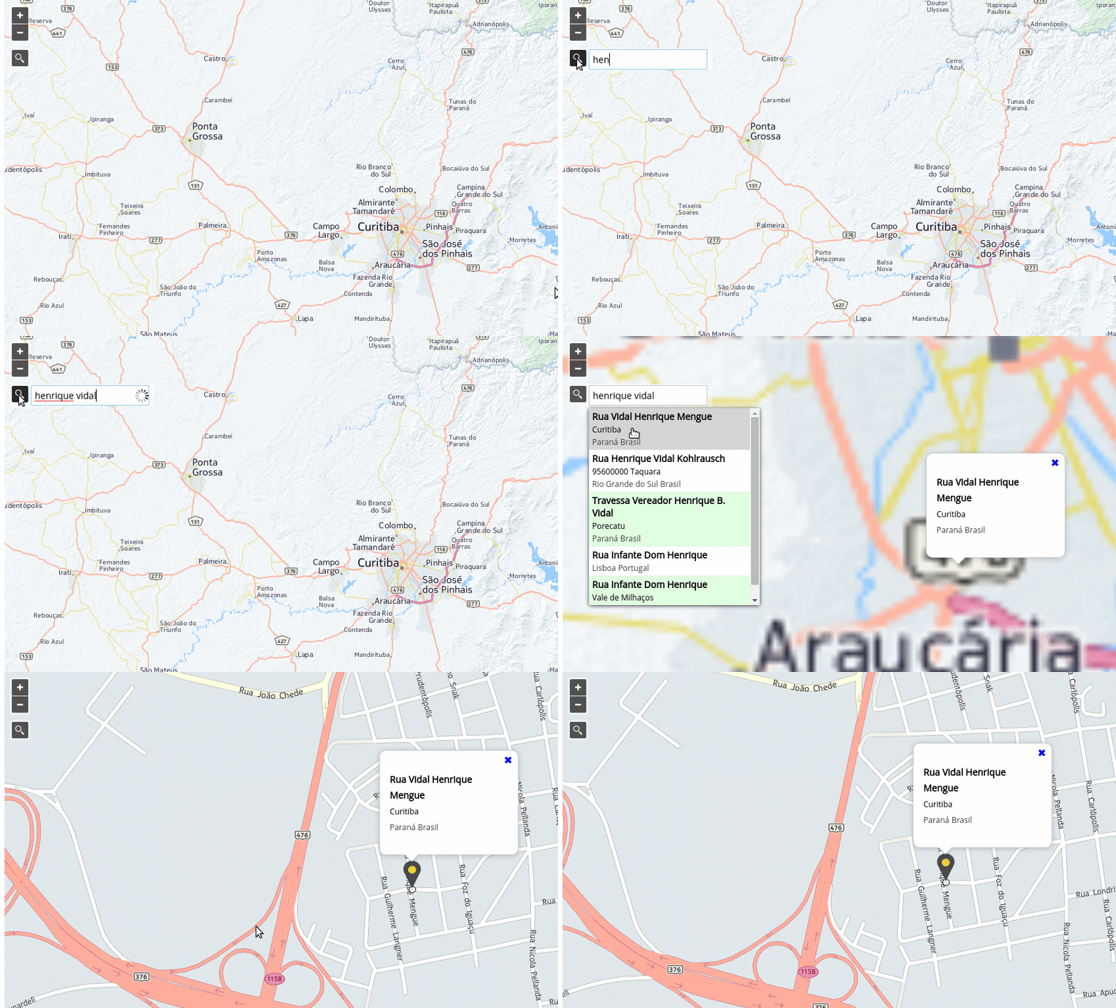
OpenLayers Control Geocoder
A geocoder extension compatible with OpenLayers v6.x to 9.0.0

Demo
You can see
- a demo of searching in nominatim/OSM
- a jsFiddle if you prefer.
- a demo of searching in proton provider using a glass button
- a demo of creating a custom provider
What's new in 4.3.4 ?
- SAME AS v43.3.3. Sorry for this unusefull commit.
- #284 keepOpen flag not working for Submit Button
- #285 The marker is an external dependency
- #286 mapquest API change
Providers
The plugin supports (for now) the following providers:
- OSM/Nominatim —
'osm'. - MapQuest Geocoding API — requires KEY —
'mapquest'. - Photon —
'photon'. - Bing — requires KEY —
'bing'. - OpenCage — requires KEY —
'opencage'.
Custom Providers
You can also write your own provider, passing an instance of it to the Geocoder constructor via the provider property of the options argument.
For an example of defining and using a custom provider see examples/custom-provider.js
Custom providers must implement the following methods:
getParameters(options)
options{Object}querySearch string entered by the user;lang{string}Preferable language;limit{number}Limit of results;
handleResponse(results)
results{Object}Parsed JSON response from API call
NPM
npm install ol-geocoder
CDN hosted - jsDelivr
Load CSS and Javascript:
<link href="https://cdn.jsdelivr.net/npm/ol-geocoder/dist/ol-geocoder.min.css" rel="stylesheet">
<script src="https://cdn.jsdelivr.net/npm/ol-geocoder/dist/ol-geocoder.js"></script>
CDN hosted - unpkg
Load CSS and Javascript:
<link href="https://unpkg.com/ol-geocoder/dist/ol-geocoder.min.css" rel="stylesheet">
<script src="https://unpkg.com/ol-geocoder/dist/ol-geocoder.js"></script>
Github pages hosted
Load CSS and Javascript:
<link href="http://dominique92.github.io/ol-geocoder/dist/ol-geocoder.min.css" rel="stylesheet">
<script src="http://dominique92.github.io/ol-geocoder/dist/ol-geocoder.js"></script>
Self hosted
Download latest release and (obviously) load CSS and Javascript.
Instantiate with some options and add the Control
const geocoder = new Geocoder('nominatim', {
  provider: 'mapquest',
  key: '__some_key__',
  lang: 'pt-BR', //en-US, fr-FR
  placeholder: 'Search for ...',
  targetType: 'text-input',
  limit: 5,
  keepOpen: true
});
map.addControl(geocoder);
Listen and do something when an address is chosen
geocoder.on('addresschosen', (evt) => {
  const feature = evt.feature,
    coord = evt.coordinate,
    address = evt.address;
  // some popup solution
  content.innerHTML = '<p>' + address.formatted + '</p>';
  overlay.setPosition(coord);
});
API
Constructor
new Geocoder(type, options)
-
type{String}- Maybe later we will have other types like'reverse'. So for now just pass'nominatim'. -
optionsis an object with the following possible properties:provider:'osm'(default),'mapquest','photon','pelias','bing','opencage', custom provider instance; Your preferable provider;url:'https://nominatim.openstreetmap.org/search''; API provider url;key:''; API Key if required;label:''; Label to display at top of input div;placeholder:'Search for an address'; Placeholder for text input;targetType:'glass-button'; Can also be'text-input';featureStyle:ol.style.Style; Feature style;lang:'en-US'; Preferable language;limit:5; Limit of results; If limit = 1 : don't display the list but directly fies to the first found;countrycodes:''; Only valid forosmandmapquest; Limit search results to a specific country (or a list of country codes separated with commasFR,US). This is an [ISO 3166-1alpha2 code] (https://en.wikipedia.org/wiki/ISO_3166-1_alpha-2), e.g.gbfor the United Kingdom,brfor Brazil, etc;viewbox:''; The preferred area to find search results. Any two corner points of the box are accepted as long as they span a real box. (string) ', , , ' x is longitude, y is latitude (EPSG:4326); keepOpen:false; Whether the results keep openned;preventDefault:false; Whether panning (and creating marker) when an address is chosen;preventPanning:false; When true, prevent panning, but create marker, when an address is chosen;preventMarker:false; When true, prevent creating marker, but provide panning, when an address is chosen;defaultFlyResolution:10; (meters per pixel) resolution to fly to when only coords & not bbox is returned by the provider;target:null; html element to attach the selector to (outside the map);debug:false; If true logs provider's response;
Instance Methods
getLayer()
Returns the layer {ol.layer.Vector} created by Geocoder control.
getSource()
Returns the source {ol.source.Vector} created by Geocoder control.
setProvider(provider)
@param {String} provider
Sets a new provider.
setProviderKey(key)
@param {String} key
Sets provider key.
Events
Triggered when an address is chosen
geocoder.on('addresschosen', function(evt) {
  // it's up to you
  console.info(evt);
});
Text input customisation
You can customize the text input control using the js parameters to
- Add a label inside the input field
- Attach the control out of the map
- One touch position access (avoid the 5 positions choice)
See the demo
Glass button customisation
You can customize the glass button using css (to include after ol-geocoder.css) For example :
/* Change the button position */
.ol-geocoder.gcd-gl-container {
  position: initial;
  float: left;
  height: 26.75px;
  width: 26.75px;
  margin: 2px !important;
}
.ol-geocoder .gcd-gl-btn {
  position: initial;
  height: 24.75px;
  width: 24.75px;
}
/* Customise the button aspect */
.ol-geocoder .gcd-gl-btn:after {
  content: "\1F50E"; /* Inverse loop */
  font-size: 15px;
}
/* Don't fotget to change the position of the input & result fields */
.ol-geocoder .gcd-gl-expanded {
  overflow: visible;
}
.ol-geocoder .gcd-gl-input {
  top: 30px;
  left: 1px;
}
.ol-geocoder .gcd-gl-search {
  top: 28px;
  left: 175px;
}
.ol-geocoder .gcd-gl-result {
  top: 61px !important;
  left: 66px !important;
}
